park st

Latest Park St bike plan misses the mark

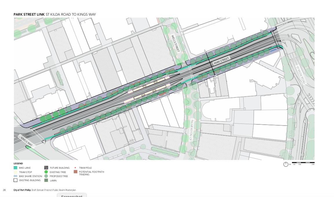
PARK ST SOUTH MELBOURNE.    At the Port Phillip Council meeting on 20th October, the Council resolved send a revised bike lane design for Park St out to consultation.    The revision is a significant downgrading of the plan presented to Council in March.  The March plan had protected, on-road lanes between St Kilda Rd and Moray St (and was a substantial improvement on the first plan).  In order to preserve parking, the new plan moves the bike lane on to the footpath between St Kilda Rd and Kings Way.    This makes it a worse experience for both pedestrians and cyclists, with no separation beyond paint, and a loss of directness as the bike lane winds up onto the footpath from the road.   It's also rated by the engineers as significantly less safe.    It's disappointing that Council has decided that walking and cycling needs to make way for parking, despite stating that their priorities are the opposite.  

Nevertheless, the project does implement the council's bike lane strategy and is an improvement on what is now there.   

Our submission to the consultation:

The current plans for the bike lanes are significantly worse than the plans proposed in March. In the earlier plan, the cycle lanes between St Kilda Road and Kingsway were protected and on-road. In this plan, they are moved onto the footpath.

This change...

* Provides a less attractive experience for cyclists, with a less direct path winding up and down from the footpath.

* Has worse sightlines, with lack of clear priority at side-streets

* Is more dangerous for pedestrians, as quantified in the supporting documents provided

* Is more dangerous for cyclists, as quantified in the supporting documents provided

* Takes space away from pedestrians, in direct contravention of the Move Live Connect strategy which is supposed to prioritise them.

This change has been implemented in order to provide a handful of car parks, again in contravention to the Move Live Connect strategy which is supposed to prioritise active transport.

Between Kings Way and Moray St, the temporary bike lanes are a very good solution and we hope they become permanent.

While the changes are an improvement to current conditions and hence we support them, they also represent a significant missed opportunity for an excellent bike connection to the new station and will be a weak point in our future network.

Please make a submission to the consultation by 12 December: https://haveyoursay.portphillip.vic.gov.au/park-street-streetscape-improvement-project

Councillor's ride of the Gateway Ward

On the 11th May, the BUG took new Port Phillip Councillors Heather Cunsolo and Peter Martin for a ride of Gateway Ward. Or maybe they took us—- they are both at home on their bikes!

BUG members Julie and Pierre with councillors Heather Cunsolo and Peter Martin

BUG members Julie and Pierre with councillors Heather Cunsolo and Peter Martin

Our first stop was the notorious bus stop near the Sandridge Lifesaving Club. This is smack in the middle of the shared path, and the large advertising posters block views of the oncoming bikes and pedestrians, as well as people waiting at the bus stop. We’ve been raising this issue since 2019. In 2020 Councillor Pearl raised it in Council, to which the General Manager replied “"if there is a bus stop that’s causing any safety issues we will report that to the Department of Transport"—- it’s not clear if that’s happened. Our Councillors indulged us by illustrating the safety issues involved.

L1610421.jpg

Next stop, the planned Garden City route. This is one of the protected bike routes from the Integrated Transport Strategy, joining Beacon Rd with Garden City Reserve and then on to the Sandridge Trail via Swallow St. The planned route will include a bidirectional trail on the west side of Beacon Rd and improved crossings on Swallow St. It’s not clear how it will deal with the roundabout between Beacon Rd and the Boulevard.

At the roundabout

At the roundabout

Next stop, the Sandridge Trail. There is still no safe crossing on Bridge St (pictured below), but the new signalised crossing on Ingles St is a big improvement.

No safe crossing of Bridge St

No safe crossing of Bridge St

There was some good news though—- at the tram depot, the Sandridge Trail was closed for works. Apparently the flooding issue (raised repeatedly by BUG members, and also identified in the BikeSpot project) is being addressed, and the notorious yellow railing chicanes are being replaced. The proposed designs look like they’ll be a much better fit for people with trailers, long bikes, or wide bikes.

Finally over to Moray St, and Park St, where Council and State Government plan to build protected bike lanes. Between St Kilda Rd and Kingsway, a planned major renovation of the road will include protected lanes. Between Kingsway and the roundabout, Council will put in temporary protected bike lanes. It’s not clear what the final layout will be.

L1610450.jpg

Thanks to Heather and Peter for coming out on a damp and windy morning, we wish you well for your term on Council.

Park St-- an eloquent plea to Port Phillip Council

An address to Port Phillip Council by Middle Park resident, and public health expert, Dr Claudia Marck, 18/9.

I’m Claudia Marck and I’ve been a resident of Port Phillip for over 10 years.
However I grew up in the Netherlands where, just like 43% of the population, I cycled daily from a young age so I’m a confident cyclist and know what good cycling infrastructure looks like.
I cycle almost daily from Middle Park to my work at Melbourne University. It keeps me fit and active. It’s an efficient and cost-effective method of getting to and from work as it’s faster and cheaper than public transport or driving. I should mention, I do also drive a car when I have to.
As a public health academic, I’m well aware of the range of health benefits of active transport. In Australia 55% of adults don’t reach recommended physical activity levels and two thirds of adults and one quarter of young people are overweight. This is a major cause of chronic disease. I can also touch on the climate emergency but others have done that already tonight. So I think the benefits of promoting cycling is overwhelming. Getting more people on bikes also clears up the road for people who have to drive because of disability or other reasons.
In terms of behaviour change, science is clear that behaviour that is learned early in life is more likely to stick. So wouldn’t it be great to get kids and young people cycling to school and help them reach recommended physical activity levels and prevent overweight and associated chronic disease. For students to cycle to universities and TAFE. For people like us to cycle to work and the supermarket and not having to take the car to the gym. The biggest problem at the moment is that it’s simply unsafe to do so.
I’ll get to my point now, I’d like to ask that you prioritise safe cycling infrastructure. What does that mean? It means bike lanes that you would feel comfortable letting young kids cycle on. This means a bike lane that is physically separated from the foot path from parked cars and most importantly, physically separated from the road. If there is no physical barrier, it means cars, taxis, Ubers, delivery vans and trucks will use bike lanes as an overtaking lane, pick up spot, loading zone or swerve into when they’re looking at their phone. This is a reality for me every single day. I get cut off, pushed into the traffic by parked cars pulling out, get doored, have to go onto the road because it’s blocked etc. This doesn’t happen on bike lanes with physical barriers.

As a driver, I also prefer a physically separated bike lane, as it can be scary overtaking cyclists on narrow roads.
So in conclusion, a safe network of connected bike lanes should be priority for a healthy and active community. I hope you can find a way to prioritise a continuous separated bike lane on Park St as part of the domain precinct master plan.

More on Park St

First post on Park St is here.

We are continuing to argue for completely separated and safe bike lanes on Park St. The draft masterplan shows separated lanes east of Kings Way, and painted lanes between car parking and moving vehicles west of Kings Way.

In August the BUG met with Port Phillip Mayor Dick Gross and council officers, who said that while active transport was being “prioritised” on this route, they did not want to lose a number of car parking places, particularly the ones in front of the properties on the north side of Park St, between Law St and Kings Way which do not have off-street parking from Park St (there is however rear lane access). The properties on the south side of the street have off-street parking.

Council’s masterplan prioritises on-street car parking here

Council’s masterplan prioritises on-street car parking here

While there is currently a lot of room on this section of Park St, the plan is for new tram tracks to be installed, as part of the Melbourne Metro project. With the new tram tracks, there will still be sufficient room for completely separated bike lanes: this is a matter of priorities.

Council plans to build the separated lanes on the east end in FY 2019/2020. The new tram tracks are not expected to be built for another 5 years or so, when Melbourne Metro is finished.

We are advocating that when council builds the east end separated lanes this year, they mark parking-protected lanes, with temporary flexible bollards, on the west end. This will allow people to connect the separated lanes on Moray St with the ones on Park St, at least for some years. Our submission is here.

Paint is not protection--- Park St Link

City of Port Phillip has released the first designs for the Park St Link, Route 3 on the planned network of protected bike lanes in the Integrated Transport Strategy (ITS). These designs are part of the Domain Masterplan, now open for consultation, until 14th August 2019.

The Park St Link is a short section connecting St Kilda Road (with its future separated lanes) at Anzac station, and Moray St (Route 3 of the ITS, which has been built as separated lanes to the north, and only “buffered” lanes to the south).

Substantial changes are proposed here, with a new tram line down the street, as well as some street closures.

Context: Park St Link (marked 3) connects St Kilda Rd with Moray St. Full map here.

Context: Park St Link (marked 3) connects St Kilda Rd with Moray St. Full map here.

The eastern section between St Kilda Road and King’s Way shows a completely separated lane, protected from vehicle movements by some kind of curb. The intersection with the minor cross-street, Wells Street, has been dealt with by building up the curbs at the entrance, indicating that the cycle lane and footpath are to have precedence.

St Kilda Road to King’s Way separated lanes

St Kilda Road to King’s Way separated lanes

However the western end of the route, from King’s Way to Heather St, is what the council calls “protected”— that is, it is a green-painted lane with car parking on the left, and vehicles to the right. The “protection” is supposed to be provided by a painted buffer on both sides. Paint will not protect people on bikes from vehicles intruding into the bike lanes. Moreover, a non-separated lane does not provide the high level of safety required to encourage vulnerable or risk-averse potential cyclists.

King’s Way to Moray Street— a non-separated lane.

King’s Way to Moray Street— a non-separated lane.

There is no apparent physical reason why such a mediocre treatment has been proposed here, rather than a Copenhagen style lane with car parking between the bike lane and the vehicle lane. There are very few driveways, with much of the section adjacent to parkland.

Based on the treatment of Moray St, the additional space requirements for a separated cycle lane are as little as 0.5m; however if required, the new tram lanes could be slightly off-set, allowing car parking on one side (as a Copenhagen lane) but not the other.

The closure of Eastern Road is commendable, with extra open space created. There is also a very short section of separated lane between Heather St and Moray St.

On the whole, this treatment fails to achieve its own stated outcome of “A safe, on-road separated bike lane to connect to other bike riding routes, including St Kilda Road, Moray Street and beyond“ (Draft Public Realm Masterplan, page 26).

It also fails to respond to the community, who said:

• Park Street to St Kilda Road is a critical connection for bike riders and needs to be closely considered.

• Big supporter of the separated bike path – following similar models like the ones used in the Netherlands.

• Separated bike path to help improve safety.

(Documented in the Domain Precinct Design Response Community Engagement Report.)

You can respond to the draft plans here—please copy your response to portphillipbug@gmail.com, so we can include your concerns when we meet with councillors. The Port Phillip BUG has also made a submission on behalf of our members.