advocacy

Community support for separated bike paths on Kerferd Rd

Press release here.

A diverse range of community and not-for-profit groups are calling on State Government to construct a safe bike lane on Kerferd Rd.   This would have many benefits for the whole community.

A separated bike lane would

  • Encourage scooter users off the footpath, ensuring that footpaths remain usable for pedestrians, particularly older people and people with a disability 

  • By making it possible for more people to ride, play an important role in improving cardiovascular health

  • By making it possible for more people to ride, reduce transport emissions that contribute to climate change

  • Enable kids and young people to make safer independent journeys to school and around town

A separated bike path along the length of Kerferd Rd-Albert Rd corridor was a key recommendation of the community panel for the Shrine to Sea project.  The panel made their recommendations after a year-long deliberative process.

A separated bike path on this corridor is supported by:

  • The Heart Foundation

  • Victoria Walks

  • Port Phillip Emergency Climate Action Network (PECAN) 

  • Bicycle Network 

  • Port Phillip Bicycle Users Group

  • Disability Resource Centre

  • Better Streets Australia

  • Port Phillip Ecocentre and Port Phillip Baykeeper

A group of about 15 people standing on the grassy median of Kerferd Rd.   It is sunny and the trees have autumn leaves.  There are about 4 bikes, a baby, and a dog.

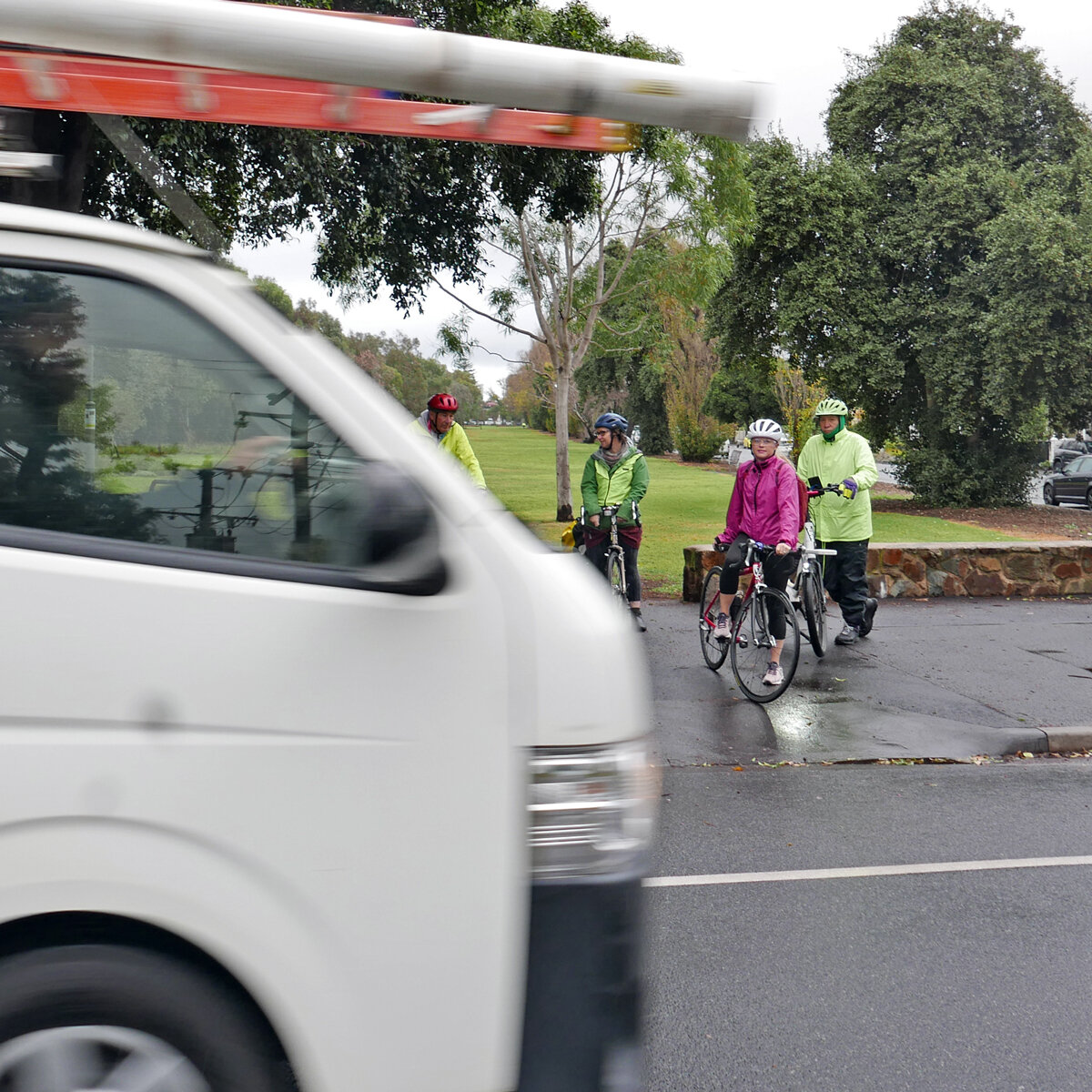
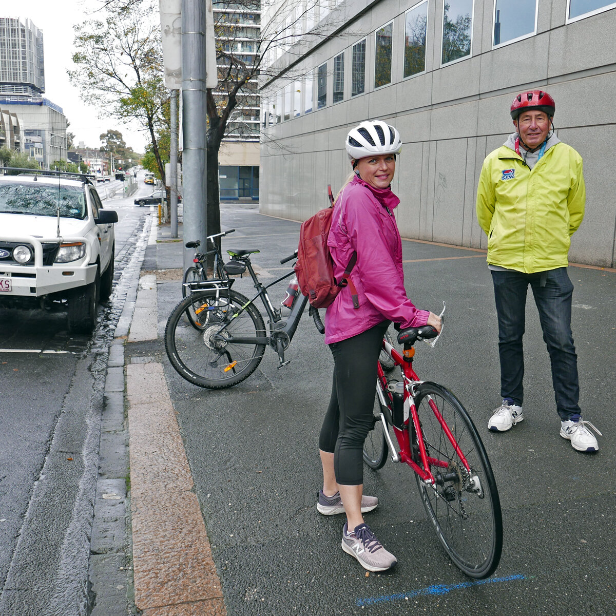
Supporters of a protected bike lane gather on Kerferd Rd.

QUOTES:

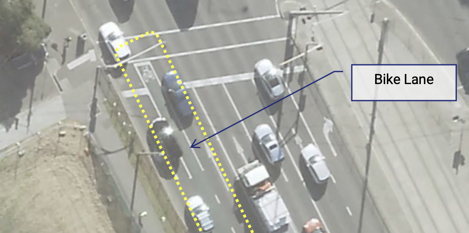
“Kerferd Rd is an extraordinarily wide corridor, with ample room for people walking, on bikes, driving and parking.  A separated bike lane would be a wonderful community asset that gives people more options for sustainable travel.  It would connect Anzac station and the new St Kilda Rd bike lanes, Albert Park, and the beach.”   

Port Phillip Bicycle Users Group president, Julie Clutterbuck.  

“The Heart Foundation supports the construction of protected bike lanes on Kerferd and Albert Roads. Active transport plays an important role in improving cardiovascular health. However, many are put-off cycling on busy roads with high levels of traffic where there is a greater risk of collision between cyclists and vehicles. Installing a separated cycle lane on Kerford and Albert Roads would help reduce potential collisions and provide cyclists with a safe and convenient way to travel by bike, making cycling a more attractive option for everybody.”

Peter Thomas, Heart Foundation National Manager,  Public and Local Affairs

Victoria Walks supports the construction of protected bike lanes on Kerferd and Albert Roads. Research has demonstrated that people walking, especially older people and those living with disability, are often intimidated sharing paths with bikes. When we surveyed seniors on walking – generally, not specific to shared paths or cycling – and asked what measures might improve feelings of safety, the top rating suggestions were:
1. Better cyclist behaviour on shared paths
2. Reduce cycling speed on shared paths

The reasons for providing separated paths are further explained in Victoria Walks’ position statements on shared paths and footpath cycling and associated background research.

The increasing popularity of e-scooters, e-bikes and other emerging devices means that attractive, separated bike lanes will only become more essential to support those transport options and ensure that footpaths remain usable for pedestrians, particularly older people and people with disability.”


Dr Ben Rossitor, Executive Officer, Victoria Walks 

“The Port Phillip Emergency Climate Action Network (PECAN) supports the construction of protected bike lanes on Kerferd and Albert Roads. This very wide corridor has ample space to share for people walking, cycling and driving safely.  We know that well-designed and networked bike lanes will increase cycling, giving Melbournians more options for sustainable active transport.   


With the recent boom in e-scooters, attractive, separated bike lanes are also essential for ensuring that footpaths remain usable for pedestrians, particularly for older people and people with disabilities.”

Rhonda Small, for PECAN Co-ordinating Group    pecan.org.au@gmail.com

“Kerferd Road is a broad boulevard through the beach-side suburb that has plenty of road space for high quality bike infrastructure.   And just as critically, the route is also mapped as a Strategic Cycling Corridor (SCC) in the government’s plan for Melbourne’s arterial bike facility network.  It runs from the Albert Park Beach to the future new Metro underground station, which is just a few years from being operational.

Bike transport is no longer discretionary.  The Kerford and Albert Road corridor has been years in the planning and is part of multiple strategies which have been subject to much review and consultation.  It is incumbent on the government to proceed swiftly, efficiently and with singular purpose.”

Bicycle Network, www.bicyclenetwork.com.au

"The BetterStreets for Victoria and Australia coalition supports the construction of protected bike lanes on Kerford and Abbott Roads. These bike lanes would support our coalition members vision for safe, healthy, people-friendly, climate-friendly streets that are accessible to all of us, to give people more options to move around safely and enjoyably. When would be a good time to make streets safe for our children? If not NOW, when? The time to choose better is now. The benefits to the community go beyond just local children, teenager, and elderly independence - these corridors would elevate tourism, access to key destinations in Melbourne and Port Phillip generating significant economic activity to local businesses."

Dr. Megan Sharkey, Board, BetterStreets for Victoria and Australia

Port Phillip Ecocentre and Port Phillip Baykeeper

“Port Phillip EcoCentre wholeheartedly supports the construction of protected bike lanes on Kerferd and Albert Roads. Availability of well-designed and networked lanes for bikes and scooters will increase choice of these modes of transport, reducing our collective carbon footprint. 

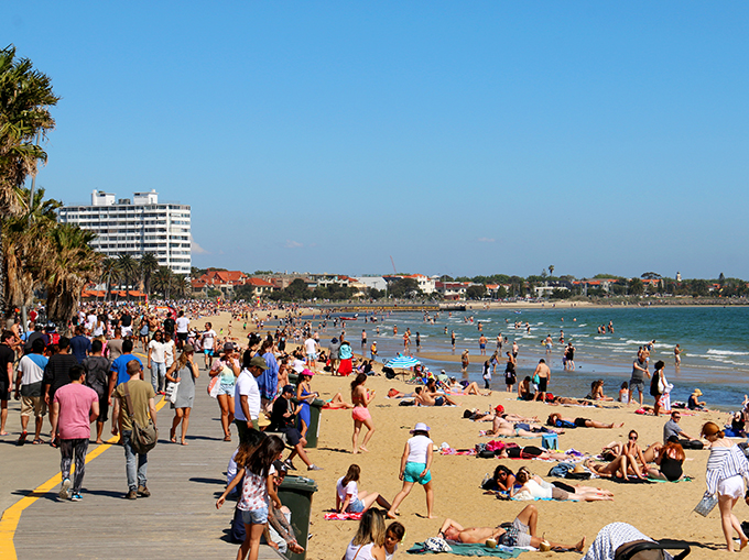
Well defined lanes clearly separating transport modes will increase safety: reducing conflict between cyclists/scooters and cars on roads, and with pedestrians on footpaths; resulting in less stress for all concerned. Provision of sustainable active transport options to the beach, will also promote personal wellbeing through more time spent enjoying our beautiful Port Phillip Bay.”

Neil Blake, Port Phillip Baykeeper.

Background on the Kerferd Rd bike lane at the Port Phillip Bicycle Users Group blog.


Turning the corner on Chapel St

Hopefully this is not just turning the corner literally—- from Chapel St into Alma Road, at the end of the March Critical Mass ride—- but we also turn the corner to a new direction for safe and fun riding on Chapel St!

Kerferd Rd bike lane (update April 2023)

TAKE action:

Write to your representatives! contact details are here.

The history

2018: The City of Port Phillip’s integrated transport strategy Move Live Connect designates Albert/Kerferd Roads as a priority bike route. CoPP prepares a Kerferd Rd safety trial, including a protected bike lane, supported by extensive traffic modelling.

However in the 2018/19 budget, the State Government committed $13m to the Shrine to Sea project, upgrading the Albert Rd/ Kerferd Rd boulevard including active transport links.

In the face of this, the Council decided not to proceed with their own trial.

The Shrine to Sea project has proceeded glacially, with extensive community consultation.

Over 2020-2021, a community panel met, considered evidence from subject matter experts, and together developed a vision for the boulevard. Among a suite of thoughtful recommendations: “Bike lanes to be interconnected for the entire length of the boulevard; Use landscaping to define a separate bike pathway on Kerferd Road to isolate bikes from cars.

Kerferd Rd bike lane, 2020

Pop-up lanes project

In 2022, VicRoads announced that as part of their pop-up bike lanes project, “40km of new and protected bike lanes” would be installed in the City of Port Phillip. Most of this was so-called “light touch” measures: renewing paint on existing on-road lanes, wayfaring signs, and speed humps.

The single substantive measure was a trial of a parking-protected bike lane on Kerferd Rd, between Richardson St and Canterbury Rd. This would include a bollard protected bike lane under the light rail near the Albert Rd/Canterbury Rd intersection. Protection from cars is essential on this stretch of road, as can be seen in the photo below.

In April 2022 VicRoads announced that following “community consultation” the trial would not go ahead.

View of the road under the light rail line, with a car partially driving in the bike lane.

Google streetview of lightrail underpass, showing a vehicle veering dangerously into the bike lane

Current situation:

The Shrine to Sea team is supposed to be releasing a draft plan in “early 2023”. They have been evaluating “5 different bike lane and road configurations”. As this is a Council road, council’s support is required for the project to go ahead. While some councillors have made their support for a protected bike lane clear, others are opposed to any changes. The support of Mayor Heather Cunsolo, who “talks the talk” on cycling, will be crucial.

Planning context

Kerferd Rd is an extraordinarily wide boulevard. At about 60m wide, it is similar to St Kilda Road, but has no tram lines or high density buildings. Few inner city streets offer such ample space for introducing simple safety improvements. There are two vehicle lanes in each direction, a very wide grassy median and a mix of angle parking and parallel parking against the curb. There are almost no driveways. After Canterbury Rd the boulevard is called Albert Rd, and runs alongside Albert Park, with service roads for much of the length. At the south-west end is the sea, at the north east end is the Shrine of Remembrance and the Domain. There are extensive sporting facilities in Albert Park, and nearby schools include Middle Park Primary, Albert Park Primary, South Melbourne Park Primary, and MacRob Girls High School.

Kerferd Rd is not a VicRoads declared road although Albert Road is. The Albert Rd/Kerferd Rd route is a State Strategic Cycling corridor, which are “the most important routes for cycling for transport”.

A map of strategic cycling corridors, showing Kerferd Rd

Strategic cycling corridors, December 2020

Albert Rd/Kerferd Rd is route 2 on the City of Port Phillip’s bicycle network, and has been identified as a high priority by Council for many years.

The need

Council’s original plan for Kerferd Rd identified the need for improvement here:

Kerferd Road has a very high number of crashes compared to other Council-managed roads in Port Phillip. Between 2016 and 2020, there were 24 recorded crashes along Kerferd Road. Of these, 11 involved cyclists; three received serious injuries. This site has the second highest number of crashes in the City of Port Phillip. This crash data has been provided by the Road Crash Information System (RCIS). This system is maintained and operated by the Department of Transport and Victoria Police.

Kerferd Road is a key link for bike riders and connects the Bay Trail bike path to the off-road paths in Albert Park Reserve, the new Anzac Station and to the proposed upgraded bike facilities on St Kilda Road and Moray Street.

Strava heat map shows high use  by cyclists

Heat map from Strava shows existing heavy bike use of Kerferd Rd, similar to St Kilda Rd or Beaconsfield Parade

What the experts say

Separated bike lanes are essential for better mental and physical health: the Heart Foundation says that Victoria should be investing in separated bike lanes improve health, as well as support local businesses, save households money, and provide independence and freedom, especially for children, teenagers, the elderly and people with a disability. They estimate that $13 would be returned in value for every $1 spent.

Separated bike lanes make financial sense: Infrastructure Victoria says “if we provide alternatives that get more cars off the road, everyone benefits. For drivers, it means less time in traffic and travelling to the city becomes a better experience. For everyone else, the environmental and productivity benefits are huge.” An increase of 55% of people choosing to cycle is achievable and could save every inner Melbourne car driver around 18 minutes in traffic per week.

People with disabilities need bike lanes to get scooters off the footpath: Vision Australia advocacy manager Chris Edwards said vision-impaired Victorians were concerned about being hit by riders or tripping over parked hire scooters. “[In] our view there’s not the infrastructure that supports [scooters] – bike lanes, appropriate places where you can park the scooters so they’re not a hazard – still hasn’t caught up. Without [that]... they’ll be an ongoing issue.” Age article, Jan 2023.

Community views

Broad-based surveys of Port Phillip residents consistently reflect support for protected bike lanes (the pop-up painted bike lanes by the DoT in 2022, on the other hand, were controversial). For example, the most popular element of Council’s Integrated Transport Strategy was “Deliver a network of dedicated and continuous priority bike lanes to create safer routes for all ages and abilities”. Surveys completed in 2018 by the City of Melbourne found that 83% of respondents living in Melbourne and adjacent municipalities (including City of Port Phillip) would aim to ride if a protected bike lane was provided compared to 22% who say they would be confident to ride on conventional painted bike lanes (without buffers).

More community views (from Heart Foundation, Victoria Walks, PECAN, and others) in a joint statement here.

The concerns raised by the anti-bike lane lobby include: “Safety - a bike track between the walking path, nature strips and the road, puts the residents at risk of tripping over the concrete bollards. Many residents along this road are elderly and transition from car, pathway and then into their property and they would be at more risk if this plan goes ahead.  Duplication - There is already a bike path for our 'much loved' bike riders. Even bike riders will not benefit from these changes. Parking - Albert Park residents pay a fee to the City of Port Phillip council to park out the front of their own homes. Yet, this plan will reduce current parking for Kerferd Rd residents.  Traffic chaos- Kerferd Road currently does not have any traffic issues. One lane WILL cause traffic to bank up at the lights at Beaconsfield Parade. Expenses - it is believed that finance (in excess of $12-16m) has already been earmarked for this project with the Victorian State Government. “

These claims are either entirely without evidence, can be mitigated by good design, or are just the cost side of the ledger, without considering the benefit side. For example: while some car parks may be lost over a rather long stretch, car parking has been prioritised under most suggested plans, and almost all of it will be retained. For example: Kerferd Rd does have traffic issues, not only the safety issues mentioned above but also hooning. Traffic modelling specific to Kerferd Rd indicates that reducing the road to one lane will not induce “traffic chaos”. For example: the expense of cycle lanes is off-set by improved public health, reduced traffic congestion, improved air quality, and reduced greenhouse emissions.

Inkerman St safe cycling corridor background

Inkerman St is one of the routes identified in the City of Port Phillip’s Integrated Transport Strategy to be prioritised for protected safe cycling. It is also classified by the Victorian government as a strategic cycling corridor.

Map of the bicycle corridors included in the Integrated Transport Strategy

In May 2021 Port Phillip council officers prepared an update on the Inkerman Safe Travel Corridor. Inkerman St between Orrong Rd and Fitzroy St was identifed as the highest priority bike corridor for council delivery.

Factors influencing this include:

  • As a connector between the (soon-to-be-completed) St Kilda Rd separated bike lanes and Caulfield station/ Monash Caulfield/the Djerring trail (under the skyrail on the Dandenong line), this is of high strategic value

  • This street has a poor safety record, with 50 crashes recorded in the 5 years to 2019, 16 involving bike riders and 17 involving pedestrians.

  • The existing narrow painted bike lanes do not mitigate the safety risks to bike riders.

  • Usage of the corridor by people on bikes is high and increasing.

OPtions for the safe cycling corridor

This report presented three options for improvement. (A fourth option, a bi-directional path on one side of the road, was not pursued due to low safety benefits.) The italicised text and images following are from the report.

Option 1: Wide protected bike lanes with parking on one side of the street

Street cross section, showing (from left to right) footpath, a tree, a bike lane, a buffer zone, a parking bay, two traffic lanes, bike lane, a tree, a footpath.

Option 1 separates the bike lane from parked cars with metre wide islands at kerb height that provide a place for passengers to enter or exit a parked vehicle. This is the safest option for all users. Inkerman Street is wide enough so that, with the removal of the central median, the bike corridor can be included without reducing the number of cars that can drive on the road.

Option 1 will require 124 of 189 parking spaces to be removed.

Option 1 is the safest option for bike riders and Council officers recommend developing a concept for this option.

Option 1 is the preferred option for keeping the street open for everyone to use: people on bikes, scooters, and e-bikes, travelling at different speeds, can easily share the bike lane. By making the protected lanes attractive for all these users, it also keeps the traffic lane free for faster-moving (40km/hr) vehicles.

Option 2: Narrow kerbside bike lanes with parking on both sides of the street.

Street cross section showing (left to right) footpath, bike lane, parking bay, two traffic lanes, parking bay, buffer, bike lane, footpath.

Option 2, like Option 1 is a kerbside bike corridor with a protective kerb. Option 2 retains more parking by reducing the width of traffic and bike lanes. This will limit areas where faster riders (including e-bikes and e-scooters) can overtake to breaks in the separator kerb including areas where there is no parking, at intersections, or they may ride in the traffic.

While Option 2 retains parking on both sides of the road, about 46 parking spaces will be removed adjacent to driveways to provide sightlines between drivers and bike riders. In addition, up to 20 spaces will be removed to support turning movements and avoid reducing intersection capacity.

Option 3: Painted buffers without a physical barrier.

The third option uses painted buffers rather than a physical barrier (low kerbs). While bike lanes with painted buffers on both sides are safer than the current painted bike lane, they do not provide a physical barrier between moving or parked cars and people riding bikes.

City of Melbourne surveys found that 22% of respondents would be confident to ride on typical bike lanes painted on roads, 46% of would aim to ride if double buffered bike lanes were provided while 86% of respondents would ride in protected bike lanes.

Buffered bike lanes require a maximum of 50 parking spaces to be removed to improve sightlines at driveways and intersections.

What about the glen eira section?

Inkerman St is in the City of Port Phillip up to Hotham St. Between Hotham and Orrong Rd it is shared between the City of Port Phillip (north) and the City of Glen Eira (south). East of Orrong it is in Glen Eira (and then named Inkerman Rd).

The City of Glen Eira’s transport strategy has a target of 50% of all trips to be taken by non-car transport by 2031. However this is purely aspirational, with few actions to support it. The main action for cycling was to “Plan and design a pilot cycle corridor improvement project with a protected cycleway to encourage an increase in cycling.” The location chosen for this corridor was Inkerman Rd, which shares the same strategic benefits as the connecting Inkerman St.

Anti-bike lane campaign Starting in 2019, there was a concerted anti-bike lane campaign by some residents of Inkerman Rd. Key concerns were safety and loss of parking (as well some other expressed concerns such as people from outside the area using “their” street). The campaign was very heated, with councillors requesting that they not be harassed by people opposing the bike lanes.

In November 2022 Glen Eira Council officers released a massive report (over 500 pages) on the Inkerman Safe Cycling Corridor Trial. They recommended a bi-directional bike lane on one side of the road. (This was probably due to it requiring fewer car park removals, despite this lay out being identified by Port Phillip as having lower safety benefits for bike riders).

On 22 November, the Council carried a motion that Council “Ceases all work on the project and no longer proceeds to community consultation”. The motion was carried 5/4 with the support of Crs Esakoff, Magee, Cade, Parasol and Zmood.

Current situation

While the eastern section in Glen Eira is a lost cause with the existing Glen Eira Council members, in Port Phillip between Hotham and Fitzroy St we can still choose to make a street that is open for everyone to use.

As of writing (March 2023) we are waiting for the Port Phillip Council to consider the concept designs prepared by Council officers. After that, it will go out to community consultation.

So called "independent expert report" on pop-up infrastructure trial is neither independent, nor expert.

 Summary: A so-called independent report claims to find that the pop-up trial of bike infrastructure is dangerous and should be removed. It is a privately commissioned piece of political advocacy that is neither transparent nor comprehensive, contains egregious errors throughout, and offers opinions not based on actual data or best practice knowledge. We stand by our call for the trial to run to completion, with a comprehensive data-driven review before deciding whether to keep or remove the changes.

Update: Since writing this article, some of our questions about the Traffix Report have been (partly) answered by PS Media article 25 November. So we suggest reading this first: https://news.psmedia.com.au/port-phillip/news/articles/2511-pop-up-bike-lane/


While the range of infrastructure implemented across 38 km of city streets is a bit of a mixed bag, our user experience survey and consultation identified no immediate safety issues [1]. We look forward to a full and proper review based on robust data at the end of the trial period.

RoPP-Traffix Report

The following is our review of the ‘Port Phillip ‘Pop-up’ Bike Lane Infrastructure Independent Transport Review’ by Traffix Group consultants, dated 27 October 2022 from the Ratepayers of Port Phillip (RoPP) Facebook page.

The Traffix report is partisan, not independent

The so-called "independent" Traffix report does not meet basic criteria for independent expert reports, such as the requirements listed in VCAT Practice Note for Expert Evidence.


The commissioning of the report lacks transparency and accountability. The report does not clearly state its funding sources, aims, methods, limitations, and assumptions. The Traffix report reviews only a small number of isolated sites within the 38 km pop-up trial and so can hardly be considered a comprehensive assessment. Yet, this does not stop the conclusion making sweeping recommendations about "the vast majority of the pop-up bike lane infrastructure.”


The consultant and client have worked together to form a closed feedback loop. An example of this can be seen in the Traffix report citing "community reporting" of "confused motorists" as a significant safety issue, which is then promoted by the RoPP spokesperson on their website and to the Nine media to claim an "independent" report has raised significant issues for motorists.


We conclude that Traffix are acting as an advocate for the political lobby group RoPP and that it is misleading to refer to their report as “independent”.


Misinformation Campaigns

If the RoPP political group had commissioned the report to address genuine safety concerns, they would have submitted it to the local and state governments for immediate action, instead of promoting it to the media.

 Like other conspiracies cooked up on facebook groups, it is alarming that real community safety issues are being deliberately misrepresented for political gain. For example, the "independent" Traffix report has been used by RoPP to try and wedge candidates for the state government election, refer to RoPP reporting on Albert Park candidates forum.

Safe cycling infrastructure

Central to all of the Traffix report's key findings and recommendations, is the fallacious opinion that "conventional" bike lane infrastructure (paint) is safer than physical separation. This opinion is directly contradicted by evidence from extensive research in Australia and internationally, such as:

·     The Conversation: 3 in 4 people want to ride a bike but are put off by lack of safe lanes

·     Separated bike lanes means safer for all users of the road: 13 year study across a dozen cities 

At Park Street, for example, Traffix consultants tie themselves in knots on this issue: acknowledging the new separated lanes are a clear safety improvement, yet also recommending extensive modifications to convert them to “conventional” painted lanes.

The image shows an unprotected bike lane between two lanes of car traffic.

The Traffix report recommends this as best practice….

Traffix also makes an overly big deal about conflicts with left-turning lanes at the newly separated intersections on Marine Parade and Park Street, even though these conflict points now occur at much lower speeds. Traffix asserts that minor concerns like this make the entire separated trial unsafe for motorists and cyclists: this is not just over-egging the issue, it is directly contradicted by the extensive research cited above.

 We strongly support the retention of the Park Street pop-up separated bike lanes. We love the new St Kilda Road separated bicycle lanes and we look forward to the Kerferd Road separated lanes being implemented as part of the Shrine to the Sea project.

Traffic Congestion

The Traffix report does not find that the pop-up trial exacerbates traffic congestion, despite this being claimed by a RoPP spokesperson on their website. To be clear, the report does not make any findings or recommendations on the issue of traffic congestion and for RoPP to claim otherwise is blatant misinformation.

Motorist Safety

The report’s conclusion claims that the overall trial offers "an increased risk to road users" including “motorists”, yet evidence in the report in support of this for this bold claim is scant.

 The report's review of separated bicycle infrastructure greatly exaggerates the increased risk of conflict between bicycles and cars, as noted above for Marine Parade and Park Street.

 The report erroneously does not identify the asymmetric nature of conflicts between bicycles and cars, with the person riding the bike obviously much more at risk than the driver and occupants of the vehicle. Deliberately conflating the two risks as being equivalent is a misrepresentation of road safety issues.

The "community reports" of "confused" motorists driving on new separated bicycle lanes in Marine Parade is most likely a teething issue associated with the introduction of new infrastructure. There is no data supporting Traffix’s claim that the bicycle lanes pose any continuing safety risk to motorists. There is also evidence that the risk to cyclists is far greater for painted bicycle lanes than for separated lanes.

 The report only identifies one isolated instance of increased risk to motorists, which relates to the circumstances at Deakin Street in St Kilda West. In this case, the report identifies some simple ways to mitigate the increased risk, namely adding a painted centreline and road narrowing warnings. However, the report fails to mention these safety solutions, or any others, in its findings and recommendations. This is an extraordinary omission for a "safety" report! Given Deakin Street's wide pavements, low traffic speed and low traffic volumes, there are many simple safety solutions that could work well for all road users in this space.

 Who is cycling infrastructure for?

Traffix's strong preference for painted bike lanes reflects outdated engineering assumptions that all cyclists are fit, adult males in lycra. As per the research cited in The Conversation, 3 in 4 people want safe cycling routes, which particularly for women, means separated cycling infrastructure.

There is community demand for safe cycling routes that better suit a wider demographic: parents doing the childcare drop-off on the way to work, kids cycling to school, families going to the beach, and seniors who like getting around by bike 'cos it's easier on the old knees' than walking. 

 Marine Parade

Marine Parade is a central part of one of Melbourne's most popular and iconic on-road cycling routes. The road has well-known safety issues, including at the intersections targeted by the pop-up trial. We therefore disagree with Traffix's recommendation that targeting safety improvements at these notorious intersections is not worthwhile. As with the rest of the trial, we look forward to a complete review being made at the end of the 12-18 months period when more data is available. 

 Apart from intersections, we note the other significant safety issue for cycling on Marine Parade is the lane interruptions by on-street parking, such as at Donovan's restaurant and at Catani Gardens.  We would welcome RoPP making a positive intervention to address these issues, rather than the crocodile tears on display here.

Get off the Road!

For the section of Marine Parade between Fitzroy Street and Glen Huntly Road, Traffix claims that the ‘pop-up’ bicycle lanes on Marine Parade “are in locations where there is already an existing two- way off-road bicycle path that runs parallel to Marine Parade adjacent to the western side of the road. This path is fully separated from traffic.”  (As an aside: professional traffic engineers ought to know the difference between a shared user path and a bicycle path).

Apart from the middle third, this statement is incorrect for the majority of this 2.2km section, because:

a.      in the southern section, from Dickens St to Glenhuntly Rd, the off-road path detours through the marina car park – where it is a shared path with pedestrians – and then makes a long detour around Moran Reserve and Point Ormond. There is no direct connection to Glenhuntly Road from the Bay Trail.

b.     in the 850m long northern section, from Shakespeare Grove to Fitzroy St, there is no two-way off-road bicycle path at all. The popular St Kilda foreshore promenade is a shared cyclist-pedestrian space. This section is a high accident zone between pedestrians, cyclists and scooters. At its busier times, the crowded promenade is not a safe place for riding bicycles or scooters.

This is what Traffix and RoPP call an “off-road bicycle path”

 Traffix’s recommendations that no safety improvements for cycling infrastructure is required for Marine Parade appears to be based on their false belief in a safe and equivalent off-road route. This incorrect assumption is repeated by RoPP on their website: “The report also notes an existing bike path completely separated from Marine Parade traffic has already been in place for many years, raising questions about why new infrastructure is needed.”

 In summary, both RoPP and Traffix recognise that the popular Marine Parade cycling routes are unsafe. However, they do not recommend any safety improvements because cyclists should just get off the road!

Visual Amenity

Making "visual amenity" a key recommendation in a "transport safety review” is highly unusual but reflects the RoPP tactic of conflating “amenity” with “safety” issues. Why else would "independent" transport engineers be so troubled by orange paint, which is the standard colour for temporary road works? “Visually uncluttered” places like St Kilda Junction are paradise to traffic engineers but deadly to cyclists!

 While we agree that permanent garden beds are preferable to temporary concrete blocks, and white paint is preferable to temporary orange paint, we are quite happy to wait until an independent safety review at the end of the 12-to-18-month trial for any final decisions to be made.

 Pedestrian Safety 

We welcome the Traffix report's findings that the pop-up trial improves pedestrian safety at many intersections. However, we completely disagree with the recommendations that pedestrian safety improvements are "irrelevant" and should be removed. We recognise that pedestrians are the most vulnerable users of public spaces and must be considered as a priority in all decisions around road safety. 

 Incremental safety improvements

Despite finding that some trial interventions have overall safety benefits, Traffix still recommend their removal because "not every intersection has that treatment". This is illogical.

 Speed Humps

We support the introduction of speed humps to reduce vehicle speeds in residential streets, as they can improve safety and amenity for the entire community. We note some fine-tuning of placement and design may be necessary in a few places, particularly to avoid vehicles swerving around the speed humps.

 Sharrows

Painted sharrows offer little safety benefits to cyclists, but we are happy for the permanent status of this paintwork to be reviewed at the end of the trial.

 Wasteful Governance

The RoPP group claim to support fiscal responsibility, yet in practice are promoting the wasteful removal of temporary infrastructure based on flawed reasoning and incomplete data.

 Inherent Limitations of the Pop-Up Trial

Given the narrow parameters of the pop-up trial roll-out – doing what is quick and easy, rather than what is necessary – we note that wider safety issues have not been addressed in the trial. For example, in some targeted locations, removing or relocating on-street parking spaces would greatly improve safety much more than the pop-up installations.


[1] We note that members of BUG have since documented concerning incidents on Westbury St that should be investigated as soon as possible. The information has been passed on to the DoT Pop-up Trial team for action.

State election 2022: voting for cycling in Prahran

Both the Port Phillip BUG and the Bicycle Network have invited candidates to complete surveys about their plans for improving cycling conditions. We report on their answers, and general material, here. Responsibility for any comment is taken by Julie Clutterbuck, c/o Ecocentre 55A Blessington St, St Kilda.

Sam Hibbins MP - Greens

Do you support separated cycling lanes on St Kilda Rd? YES.

Do you support upgrading the strategic cycling corridors to separated bike lanes? YES.

Other policies: The Victorian Greens have committed $2.5 billion dollars over the next four years to implement a ‘Big Bike Build’ with hundreds of kilometres of safe and separated bike superhighways across the state.

With transport as Victoria’s biggest growing source of emissions, governments must do more to support people to make the switch to climate-friendly transport like bike riding and walking. The Greens’ plan would move Victoria towards the goal of active transport funding being 10 - 20 per cent of transport capital funding as recommended by the United Nations.

I’ve successfully pushed for the construction of separated bike lanes on St Kilda Rd and for the installation of a pedestrian crossing at Yarra Street to serve the busy South Yarra station.

My priorities now are to extend the St Kilda Rd bike lanes to Elsternwick and create a bike superhighway through to the northern suburbs , install separated bike lanes on Chapel Street North which connects directly to the Yarra trail, and a number of other local separated bike lane projects to help make riding a bike safe for everyone

Policy link: https://greens.org.au/vic/platform/transport#safer-bike-lanes

We need a protected bike lane trial on Kerferd Rd

The history

2018: The City of Port Phillip’s integrated transport strategy Move Live Connect designates Albert/Kerferd Roads as a priority bike route. CoPP prepares a Kerferd Rd safety trial, including a protected bike lane, supported by extensive traffic modelling.

However in the 2018/19 budget, the State Government committed $13m to the Shrine to Sea project, upgrading the Albert Rd/ Kerferd Rd boulevard including active transport links.

In the face of this, the Council decided not to proceed with their own trial.

The Shrine to Sea project has proceeded glacially, with extensive community consultation, and a draft design expected to go out for consultation in 2022.

Kerferd Rd bike lane current condition

Pop-up lanes project

In 2022, VicRoads announced that as part of their pop-up bike lanes project, “40km of new and protected bike lanes” would be installed in the City of Port Phillip. Most of this was so-called “light touch” measures: renewing paint on existing on-road lanes, wayfaring signs, and speed humps.

The single substantive measure was a trial of a parking-protected bike lane on Kerferd Rd, between Richardson St and Canterbury Rd. This would include a bollard protected bike lane under the light rail near the Albert Rd/Canterbury Rd intersection. Protection from cars is essential on this stretch of road, as can be seen in the photo below.

In April 2022 VicRoads announced that following “community consultation” the trial would not go ahead.

View of the road under the light rail line, with a car partially driving in the bike lane.

Google streetview of lightrail underpass, showing a vehicle veering dangerously into the bike lane

Planning context

Kerferd Rd is an extraordinarily wide boulevard. Few inner city streets offer such ample space for introducing simple safety improvements. There are two vehicle lanes in each direction, a very wide grassy median and a mix of angle parking and parallel parking against the curb. There are almost no driveways. After Canterbury Rd it becomes Albert Rd, and runs alongside Albert Park, with service roads for much of the length. At the south-west end is the sea, at the north east end is the Shrine of Remembrance and the Domain. There are extensive sporting facilities in Albert Park, and nearby schools include Middle Park Primary, Albert Park Primary, South Melbourne Park Primary, and MacRob Girls High School.

Kerferd Rd is not a VicRoads declared road although Albert Road is. The Albert Rd/Kerferd Rd route is a State Strategic Cycling corridor, which are “the most important routes for cycling for transport”.

A map of strategic cycling corridors, showing Kerferd Rd

Strategic cycling corridors, December 2020

Albert Rd/Kerferd Rd is route 2 on the City of Port Phillip’s bicycle network, and has been identified as a high priority by Council for many years.

The need

Council’s original plan for Kerferd Rd identified the need for improvement here:

Kerferd Road has a very high number of crashes compared to other Council-managed roads in Port Phillip. In the five-year period ending in June 2017, there were 25 recorded crashes on Kerferd Road that resulted in injury to bike riders, drivers and pedestrians.

  • 15 crashes resulted in injury to bike riders

  • 1 crash resulted in injury to a pedestrian

  • 10 crashes caused serious injuries

Kerferd Road is a key link for bike riders and connects the Bay Trail bike path to the off-road paths in Albert Park Reserve, the new Anzac Station and to the proposed upgraded bike facilities on St Kilda Road and Moray Street.

Strava heat map shows high use  by cyclists

Heat map from Strava shows existing heavy bike use of Kerferd Rd, similar to St Kilda Rd or Beaconsfield Parade

What the experts say

Separated bike lanes are essential for better mental and physical health: the Heart Foundation says that Victoria should be investing in separated bike lanes improve health, as well as support local businesses, save households money, and provide independence and freedom, especially for children, teenagers, the elderly and people with a disability. They estimate that $13 would be returned in value for every $1 spent.

Separated bike lanes make financial sense: Infrastructure Victoria says “if we provide alternatives that get more cars off the road, everyone benefits. For drivers, it means less time in traffic and travelling to the city becomes a better experience. For everyone else, the environmental and productivity benefits are huge.”

Community concerns

Many community concerns were raised about the trial, include a scaremongering petition that was circulated claiming that the trial would “mean a loss of parking spots, a bike lane (where one already exists) and using ugly concrete bollards between the nature strip and the parked cars”.

From the anti-bike-lane-petition.  Reasons for signing "My cat loves to walk down the road freely and without a care in the world.  NO CHANGES TO KERFERD RD"

Screenshot from the anti-bike lane trial petition

Rather than respond to these concerns with either modifying the design or by correcting misinformation, or even by pointing out that a trial would give everyone the chance to identify issues and correct them, VicRoads abandoned the project.

Sign ouR Petition to Local Member of Parliament, Minister Martin Foley, and Roads Minister, Ben Carroll.

In our petition, we ask for the re-instatement of the trial. This will allow any issues to be addressed ahead of the planned installation of permanent, separated bike lanes in the Shrine to Sea project.

Latest Park St bike plan misses the mark

PARK ST SOUTH MELBOURNE.    At the Port Phillip Council meeting on 20th October, the Council resolved send a revised bike lane design for Park St out to consultation.    The revision is a significant downgrading of the plan presented to Council in March.  The March plan had protected, on-road lanes between St Kilda Rd and Moray St (and was a substantial improvement on the first plan).  In order to preserve parking, the new plan moves the bike lane on to the footpath between St Kilda Rd and Kings Way.    This makes it a worse experience for both pedestrians and cyclists, with no separation beyond paint, and a loss of directness as the bike lane winds up onto the footpath from the road.   It's also rated by the engineers as significantly less safe.    It's disappointing that Council has decided that walking and cycling needs to make way for parking, despite stating that their priorities are the opposite.  

Nevertheless, the project does implement the council's bike lane strategy and is an improvement on what is now there.   

Our submission to the consultation:

The current plans for the bike lanes are significantly worse than the plans proposed in March. In the earlier plan, the cycle lanes between St Kilda Road and Kingsway were protected and on-road. In this plan, they are moved onto the footpath.

This change...

* Provides a less attractive experience for cyclists, with a less direct path winding up and down from the footpath.

* Has worse sightlines, with lack of clear priority at side-streets

* Is more dangerous for pedestrians, as quantified in the supporting documents provided

* Is more dangerous for cyclists, as quantified in the supporting documents provided

* Takes space away from pedestrians, in direct contravention of the Move Live Connect strategy which is supposed to prioritise them.

This change has been implemented in order to provide a handful of car parks, again in contravention to the Move Live Connect strategy which is supposed to prioritise active transport.

Between Kings Way and Moray St, the temporary bike lanes are a very good solution and we hope they become permanent.

While the changes are an improvement to current conditions and hence we support them, they also represent a significant missed opportunity for an excellent bike connection to the new station and will be a weak point in our future network.

Please make a submission to the consultation by 12 December: https://haveyoursay.portphillip.vic.gov.au/park-street-streetscape-improvement-project

Councillor's ride of the Gateway Ward

On the 11th May, the BUG took new Port Phillip Councillors Heather Cunsolo and Peter Martin for a ride of Gateway Ward. Or maybe they took us—- they are both at home on their bikes!

BUG members Julie and Pierre with councillors Heather Cunsolo and Peter Martin

BUG members Julie and Pierre with councillors Heather Cunsolo and Peter Martin

Our first stop was the notorious bus stop near the Sandridge Lifesaving Club. This is smack in the middle of the shared path, and the large advertising posters block views of the oncoming bikes and pedestrians, as well as people waiting at the bus stop. We’ve been raising this issue since 2019. In 2020 Councillor Pearl raised it in Council, to which the General Manager replied “"if there is a bus stop that’s causing any safety issues we will report that to the Department of Transport"—- it’s not clear if that’s happened. Our Councillors indulged us by illustrating the safety issues involved.

L1610421.jpg

Next stop, the planned Garden City route. This is one of the protected bike routes from the Integrated Transport Strategy, joining Beacon Rd with Garden City Reserve and then on to the Sandridge Trail via Swallow St. The planned route will include a bidirectional trail on the west side of Beacon Rd and improved crossings on Swallow St. It’s not clear how it will deal with the roundabout between Beacon Rd and the Boulevard.

At the roundabout

At the roundabout

Next stop, the Sandridge Trail. There is still no safe crossing on Bridge St (pictured below), but the new signalised crossing on Ingles St is a big improvement.

No safe crossing of Bridge St

No safe crossing of Bridge St

There was some good news though—- at the tram depot, the Sandridge Trail was closed for works. Apparently the flooding issue (raised repeatedly by BUG members, and also identified in the BikeSpot project) is being addressed, and the notorious yellow railing chicanes are being replaced. The proposed designs look like they’ll be a much better fit for people with trailers, long bikes, or wide bikes.

Finally over to Moray St, and Park St, where Council and State Government plan to build protected bike lanes. Between St Kilda Rd and Kingsway, a planned major renovation of the road will include protected lanes. Between Kingsway and the roundabout, Council will put in temporary protected bike lanes. It’s not clear what the final layout will be.

L1610450.jpg

Thanks to Heather and Peter for coming out on a damp and windy morning, we wish you well for your term on Council.

Council elections October 2020

We’ve looked at the bike-related policies and actions of the candidates, both incumbent and new. The summary is here, and our reasons are below. Candidates in bold are incumbent, and have been rated on their track records in council. New candidates are rated on their intentions.

Highly recommended Recommended Not recommended
CANAL   Tim Baxter Dick Gross Steven Armstrong
Louise Crawford Warwick Cahir
Lesley Pianella Rhonda Clarke
Denis Bilic
Maddy Blay
LAKE Katherine Copsey Robbie Nyaguy Andrew Bond
Geoffrey Conaghan Adrian Jackson
Roger Ward Bernard Mandile
Christina Sirakoff
GATEWAY Earl James Marcus Pearl
Heather Cunsolo Sami Maher
Peter Martin
Stan Gyles

The current council has made significant progress on planning for building separated bike infrastructure.   Actually building the infrastructure has been slow, and mostly dependent on outside agencies:  for example, the excellent protected Moray St bike lane was built as part of the Melbourne Metro project.

Many candidates responded to the Bicycle Network with their plans for cycling: see responses here.

We have considered all incumbents that are standing for re-election on their votes in support of cycling on three main issues.  The most important of these is the ITS, so it is worth 2 points, and the others 1 each.

Integrated Transport Strategy.   In 2018 Council endorsed a transport strategy that included building a network of protected bike routes.   FOR: Crs Voss, Baxter, Brand, Copsey, Crawford, Gross and Simic AGAINST: Crs Bond and Pearl.

Park St bike lane:  In September 2019, the council considered the Domain masterplan, which (contrary to the intention of the integrated transport strategy) had only partially separated bike lanes shown.   A motion was proposed to modify the plan to have a fully protected bike lane, particularly between Kings Way and Moray St.   In favour:   Copsey, Baxter, Simic.  Against: Bond, Voss, Brand, Crawford and Gross.  The motion later unanimously carried was to "consider the feasibility of a protected bike lane", and to undertake community consultation on it.

Recent budget:  The pandemic has brought pressure to bear on Council's budget, and one very short-sighted proposal was to cut the bike infrastructure program.   A counter-proposal was to work with State government to build temporary bike lanes for safe travels post-covid, and install low-cost "shimmy" routes along quiet streets.   In favour:  Crs Voss, Baxter, Brand, Copsey, Crawford, Gross and Simic.  Against: Crs Bond and Cr Pearl. 

Other actions:  while votes in Council are important, we also note that Councillors have been fantastic at participating in our regular rides to look at infrastructure problems and opportunities.  All re-contesting candidates save for Cr Pearl have come along at least once, and Cr Gross has been on every. single. ride.  

For the new candidates, we have used the survey by Progressive Port Phillip, which asked the question  "Do you support expanding and connecting the municipality’s bike lane and bike path networks, even if these projects are solely funded by council?" We have not listed candidates who did not return the survey, with the exception of the “Ratepayers of Port Phillip” group. Their leaflets claim bike lanes are “stealing roads and parking spaces”. These people do not support cycling. New candidates are either recommended or not recommended (since we do not know their track record, only their intentions).

CANAL WARD: Incumbents:  Highly recommended Tim Baxter (Greens), 4/4. Recommended: Dick Gross (Labor) and Louise Crawford (Labor) 3/4.  Louise Crawford has supported building bike lanes, but also places a high priority on street parking.

New candidates:  In response to the survey question, Lesley Pianella, Denis Bilic and Maddy Blay support building bike lanes.

Steven Armstrong is "not sure".  Warwick Cahir supports "well planned bike routes that do not have a detrimental effect on the traffic and parking of the area they are located in".   Given that almost all the planned routes will require removal of some parking, don't vote for Warwick if you'd like more protected lanes.

LAKESIDE WARD:  Incumbents:  Highly recommended-  Katherine Copsey (Greens) 4/4, moreover has been actively proposing bike-friendly policy.  Recommended:  David Brand (Labor) 3/4.   Not recommended: Andrew Bond 0/4.

New candidates:    In response to the survey question, Robbie Nyaguy and Roger Ward support bike lanes. Geoffrey Conaghan is “not sure” but responded to the Bicycle Network with a well-thought out response.

Adrian Jackson states "Bikes can use the roads like any other wheeled vehicle" (!).  Bernard Mandile is “not sure”.  

GATEWAY WARD:  Incumbent:  Not recommended: Marcus Pearl 0/4. 

New candidates:  In response to the survey question, Stan Gyles and Earl James support bike lanes. Heather Cunsolo is "not sure" she supports bike lanes (but is a bike rider herself and came to the BUG's September meeting);   Peter Martin is also "not sure" but says he supports them in principle.  

Comments or corrections should be sent to portphillipbug@gmail.com

Responsibility for election comment is taken by J. Clutterbuck, 93 Spray St Elwood.

Good news for cycling in the August budget from City of Port Phillip

Good news for cycling for a change! At Council meeting on Wednesday 19th August, it was resolved:   "The 20/21 Budget also recognises the pandemic has influenced how we travel with extra bike riding initiatives including:

  • Installing a temporary protected bike lane on Park Street, between, Moray Street and Kings Way, to extend to St Kilda Road ($150,000)

  • Contributing to the development of temporary central safety improvements for riders along St Kilda Road, from St Kilda Junction, to the CBD, subject to the Victorian Government funding the balance ($280,000)

  • Contributing to developing temporary safety improvements for bike riders along Jacka Boulevard and Beaconsfield Parade, subject to the Victorian Government funding the balance ($250,000)

  • Approximately $150,000 to develop shimmy bike routes (informal bike riding routes connecting to local shopping strips). This involves selecting quiet street bike riding connections, marked with bike symbols, signage and safety treatments at key locations. The symbols and signage provide ‘breadcrumb trails’ for people to follow across the City

  • About $100,000 to improve accessibility issues at the St Kilda Junction."

The shimmy routes are St Kilda to Prahran via Dickens and Westbury; Elwood to St Kilda via Beach St, Broadway and Mitford; and St Kilda to South Melbourne, along Richardson St.  These line up with bike routes promised in the Integrated Cycling Strategy (Routes 7-8, 9, and 12 respectively).   Thanks particularly to Councillors Katherine Copsey, Dick Gross, Louise Crawford, and to Mayor Bernadene Voss for all their hard work on this.     It's worth listening to Cr Gross's impassioned speech in favour (here, starting at 2:08).   Support also came from Crs Baxter, Simic, and Brand.   (It was disappointing that Councillor Bond opposed this,  given that he's said that he supports safe cycling lanes on St Kilda Rd.) 

The routes on St Kilda Rd and Beaconsfield Parade require funding from State Government.      Please email Minister Ben Carroll  ben.carroll@parliament.vic.gov.au and ask him to come on board with this.

This follows some years of work from the BUG:  we've been advocating for bike lanes, participating in the budget processes,  proposing the temporary bike lane along Park St, making contact with our Councillors.  And we couldn't do it without all of you--- thanks for

  • writing to Councillors

  • coming along on our Councillors' rides in the past couple of years

  • participating in consultations

  • and most of all getting out there and riding.

Hooray!   

Safe space for cycling and walking

Proposal: that the City of Port Phillip and VicRoads install pop-up bikes lanes on key routes to ensure safe distancing during exercise and commuting. We also request that Council widens footpaths in well-used shopping streets to allow safe space for walking.

During the pandemic shut down, we’ve seen popular recreational routes (such as the Bay Trail) become quite busy, with poor prospects for maintaining social distancing.

As we consider easing restrictions and returning to work, maintaining social distancing on public transport will be challenging and by some estimates, will reduce capacity by 90%.

In order to ensure safe exercising now and safe commuting in the future, we are asking CoPP to install temporary bike lanes with bollards, water barriers, or even by just removing parking lanes.

Precedents: This has been implemented extensively overseas in cities such as Berlin and Milan, and also by the City of Melbourne.

Supporting council’s long-term transport planning: The routes we suggest below are either State strategic bike routes, or part of the Council’s planned bicycle network. Pop-up bicycle lanes in these locations would support a more informed consultation process when the time comes to consider making them permanent.

Suggested routes: Prioritise routes that are popular for recreation, key commuter routes, or routes where there are ample alternatives for car parking or vehicle traffic, and routes that join up with City of Melbourne improved routes.

  • Beach Road/ Marine Parade/ Beaconsfield Parade: This is a popular com- muter cycle route, yet on the beach side there is no continuous on-road bike lane, and on the other side, it is in the door zone. Even with reduced motor traffic volumes, it is unsafe. Furthermore, installing a pop-up bike lane would take pressure off the parallel Bay Trail, which has become very crowded with joggers and recreational cyclists. This could easily be done by re-allocating the clear way/car parking along Beaconsfield Parade into an on-road bike lane, protected by temporary bollards.

  • St Kilda Rd: A key commuter route, and one that was recognised by the RACV Strategic Cycling corridor review (January 2019) as offering the most potential for meeting the objectives of the Victorian Cycling Strategy. Again, this could be easily done by removing car parking, or reallocating a traffic lane.

  • Chapel St: Another important commuter route recognised by the RACV review, and one where the car parking could be removed to form a bike lane.

  • Albert Rd/ Kerferd Rd: There are plans for separated bike routes (with State government agencies leading), but in the meantime temporary bike routes can be installed. Council has already made extensive traffic studies of this route.

  • Moray St: An important commuter route connecting to the City of Melbourne. This has protected cycle routes on half its length already.

Safe space for walking: We also suggest widening footpaths in well-used retail areas. As cafes and restaurants have moved to take-away only, on our narrow streets it’s difficult for customers to queue while leaving room for pedestrians to safely walk past.

  • Allow shop owners the option of reserving curbside car parking areas directly in front of their shops as "safe space for standing" zones, marked off by bollards or the like.

  • Re-allocate curbside carparks in retail streets with narrow footpaths to walking. Suitable streets here include stretches of Carlisle St, Bay St, Barkly St, and Ormond Rd Elwood.

Councillor's Ride February 2020

Our latest Councillor’s ride was for Canal Ward, but in fact we spent a good deal of time in Lake Ward. Our focus was the planned protected bike routes on council’s Integrated Transport Strategy.

Slightly blurry, but the traditional pre-ride photo!

Slightly blurry, but the traditional pre-ride photo!

Councillors Tim Baxter, Katherine Copsey, Dick Gross and Louise Crawford joined us. Mayor Bernadene Voss sent her apologies, as did local MPs James Newbury and Martin Foley.

The route we took is here. Highlights were:

  • Old bike friendly pinch points on north end of Tennyson St, Elwood. While these are a little narrow for people on wide bikes or trailers, they do the job of traffic calming while keeping people on bikes from being squeezed. We compared this to the new plastic medians further south on Tennyson. The councillors indicated that those pinch points were a mistake and would not be repeated (and some have been removed).

  • Future ITS bike route 8, on Dickens St. This is a fairly wide street forming a great connection between Balaclava and the beach. Currently there is very little bike infrastructure on the route, though there is an advanced stop box at Beach Rd.

  • St Kilda Marina. The council is currently planning the renovation of this. The design will be done by the successful private tenderer, but the guidelines emphasise the primacy of pedestrian and cyclist movement through the site. There were some different opinions about the possibility of a drawbridge across the entrance—- while this would give people more access to the breakwater, it also has an estimated cost of $5 million.

  • Bay Trail between Marina and the Jetty. We spoke about the conflict in these areas at peak times, with cyclists who just want to pass through mixing it with pedestrians, dawdlers and tourists enjoying the space. We suggested the possibility of re-routing the path behind the sea baths. Another possibility is to make the on-road lane fully separated at this point, to accommodate both the roadies and the people using the Bay Trail.

  • Bay Trail at Catani Gardens. In 2019 the Bay Trail here was closed for two weeks to accommodate a music festival, with cyclists given a so-called “detour” along Beaconsfield Parade. This was not suitable for many Bay Trail users. The councillors said that that would not be repeated, so thank you to everyone who gave feedback to council at the time.

  • Connection between the Bay Trail and Fitzroy St. This is a bit of a mess.

  • Fitzroy St. The bidirectional trail here is often nominated as one of the areas where cyclists feel least safe, because drivers do not think to look for people travelling in the counterflow direction. Let’s not build more of these.

  • ITS route 6, Grey St and Inkerman St. Glen Eira Council recently confirmed that the continuation of this route, along Inkerman Rd to Caulfield, will be their Safe Cycling Corridor pilot project. It will connect the off-road bike path below the SkyRail, to the future protected bike lanes on St Kilda Rd. This is currently quite challenging to ride, with Grey St having no bike lanes and Inkerman St having only narrow lanes in the door zone. We discussed whether it would be possible to retain two lanes of parking on Inkerman St with separated bike lanes. There is currently a median that could be removed to free up space for this.

DSC_1212.JPG

Thanks to every one who came along!

BUG advocacy priorities for 2020

We surveyed our members and supporters to find out where we should focus our advocacy efforts. Here are our top 10 for 2020:

  1. St Kilda Rd separated bike lanes

  2. Pedestrian/cyclist conflict on the Bay Trail near the St Kilda Sea Baths

  3. Poor connections between the City of Port Phillip and the City of Melbourne

  4. Ensure all routes planned on the Integrated Transport Strategy are built on time and fully protected

  5. Improve the bike lane on Chapel St (currently in the door zone)

  6. Remove railing chicanes at the tram depot on the Sandridge Trail

  7. Replace the bidirectional bike lane on Fitzroy St with two one-way separated lanes

  8. Dangerous intersection at corner of Cecil St and City Rd

  9. Signalisation of intersection of Elwood Canal path/Glen Huntly Rd

  10. Ensure adequate bicycle routes for Fishermans’ Bend are constructed

Latest information on these issues is in our big spreadsheet.

Thanks also to everyone who offered to help out. We will be in touch!

Park St-- an eloquent plea to Port Phillip Council

An address to Port Phillip Council by Middle Park resident, and public health expert, Dr Claudia Marck, 18/9.

I’m Claudia Marck and I’ve been a resident of Port Phillip for over 10 years.
However I grew up in the Netherlands where, just like 43% of the population, I cycled daily from a young age so I’m a confident cyclist and know what good cycling infrastructure looks like.
I cycle almost daily from Middle Park to my work at Melbourne University. It keeps me fit and active. It’s an efficient and cost-effective method of getting to and from work as it’s faster and cheaper than public transport or driving. I should mention, I do also drive a car when I have to.
As a public health academic, I’m well aware of the range of health benefits of active transport. In Australia 55% of adults don’t reach recommended physical activity levels and two thirds of adults and one quarter of young people are overweight. This is a major cause of chronic disease. I can also touch on the climate emergency but others have done that already tonight. So I think the benefits of promoting cycling is overwhelming. Getting more people on bikes also clears up the road for people who have to drive because of disability or other reasons.
In terms of behaviour change, science is clear that behaviour that is learned early in life is more likely to stick. So wouldn’t it be great to get kids and young people cycling to school and help them reach recommended physical activity levels and prevent overweight and associated chronic disease. For students to cycle to universities and TAFE. For people like us to cycle to work and the supermarket and not having to take the car to the gym. The biggest problem at the moment is that it’s simply unsafe to do so.
I’ll get to my point now, I’d like to ask that you prioritise safe cycling infrastructure. What does that mean? It means bike lanes that you would feel comfortable letting young kids cycle on. This means a bike lane that is physically separated from the foot path from parked cars and most importantly, physically separated from the road. If there is no physical barrier, it means cars, taxis, Ubers, delivery vans and trucks will use bike lanes as an overtaking lane, pick up spot, loading zone or swerve into when they’re looking at their phone. This is a reality for me every single day. I get cut off, pushed into the traffic by parked cars pulling out, get doored, have to go onto the road because it’s blocked etc. This doesn’t happen on bike lanes with physical barriers.

As a driver, I also prefer a physically separated bike lane, as it can be scary overtaking cyclists on narrow roads.
So in conclusion, a safe network of connected bike lanes should be priority for a healthy and active community. I hope you can find a way to prioritise a continuous separated bike lane on Park St as part of the domain precinct master plan.

More on Park St

First post on Park St is here.

We are continuing to argue for completely separated and safe bike lanes on Park St. The draft masterplan shows separated lanes east of Kings Way, and painted lanes between car parking and moving vehicles west of Kings Way.

In August the BUG met with Port Phillip Mayor Dick Gross and council officers, who said that while active transport was being “prioritised” on this route, they did not want to lose a number of car parking places, particularly the ones in front of the properties on the north side of Park St, between Law St and Kings Way which do not have off-street parking from Park St (there is however rear lane access). The properties on the south side of the street have off-street parking.

Council’s masterplan prioritises on-street car parking here

Council’s masterplan prioritises on-street car parking here

While there is currently a lot of room on this section of Park St, the plan is for new tram tracks to be installed, as part of the Melbourne Metro project. With the new tram tracks, there will still be sufficient room for completely separated bike lanes: this is a matter of priorities.

Council plans to build the separated lanes on the east end in FY 2019/2020. The new tram tracks are not expected to be built for another 5 years or so, when Melbourne Metro is finished.

We are advocating that when council builds the east end separated lanes this year, they mark parking-protected lanes, with temporary flexible bollards, on the west end. This will allow people to connect the separated lanes on Moray St with the ones on Park St, at least for some years. Our submission is here.

Paint is not protection--- Park St Link

City of Port Phillip has released the first designs for the Park St Link, Route 3 on the planned network of protected bike lanes in the Integrated Transport Strategy (ITS). These designs are part of the Domain Masterplan, now open for consultation, until 14th August 2019.

The Park St Link is a short section connecting St Kilda Road (with its future separated lanes) at Anzac station, and Moray St (Route 3 of the ITS, which has been built as separated lanes to the north, and only “buffered” lanes to the south).

Substantial changes are proposed here, with a new tram line down the street, as well as some street closures.

Context: Park St Link (marked 3) connects St Kilda Rd with Moray St. Full map here.

Context: Park St Link (marked 3) connects St Kilda Rd with Moray St. Full map here.

The eastern section between St Kilda Road and King’s Way shows a completely separated lane, protected from vehicle movements by some kind of curb. The intersection with the minor cross-street, Wells Street, has been dealt with by building up the curbs at the entrance, indicating that the cycle lane and footpath are to have precedence.

St Kilda Road to King’s Way separated lanes

St Kilda Road to King’s Way separated lanes

However the western end of the route, from King’s Way to Heather St, is what the council calls “protected”— that is, it is a green-painted lane with car parking on the left, and vehicles to the right. The “protection” is supposed to be provided by a painted buffer on both sides. Paint will not protect people on bikes from vehicles intruding into the bike lanes. Moreover, a non-separated lane does not provide the high level of safety required to encourage vulnerable or risk-averse potential cyclists.

King’s Way to Moray Street— a non-separated lane.

King’s Way to Moray Street— a non-separated lane.

There is no apparent physical reason why such a mediocre treatment has been proposed here, rather than a Copenhagen style lane with car parking between the bike lane and the vehicle lane. There are very few driveways, with much of the section adjacent to parkland.

Based on the treatment of Moray St, the additional space requirements for a separated cycle lane are as little as 0.5m; however if required, the new tram lanes could be slightly off-set, allowing car parking on one side (as a Copenhagen lane) but not the other.

The closure of Eastern Road is commendable, with extra open space created. There is also a very short section of separated lane between Heather St and Moray St.

On the whole, this treatment fails to achieve its own stated outcome of “A safe, on-road separated bike lane to connect to other bike riding routes, including St Kilda Road, Moray Street and beyond“ (Draft Public Realm Masterplan, page 26).

It also fails to respond to the community, who said:

• Park Street to St Kilda Road is a critical connection for bike riders and needs to be closely considered.

• Big supporter of the separated bike path – following similar models like the ones used in the Netherlands.

• Separated bike path to help improve safety.

(Documented in the Domain Precinct Design Response Community Engagement Report.)

You can respond to the draft plans here—please copy your response to portphillipbug@gmail.com, so we can include your concerns when we meet with councillors. The Port Phillip BUG has also made a submission on behalf of our members.

Councillors' Ride of the Gateway Ward

On Saturday 30th March the BUG took Councillor Ogy Simic and Mayor Dick Gross for a ride around Gateway Ward to look at some bicycle infrastructure, both the problems and the good new things. Our route and list of issues is here.

Despite the chilly temperature, strong winds and looming grey clouds, we were lucky to get sunshine to ride in. Here we are starting at the Port Melbourne Rotunda.

Despite the chilly temperature, strong winds and looming grey clouds, we were lucky to get sunshine to ride in. Here we are starting at the Port Melbourne Rotunda.

We made an early stop on the Bay Trail at the Sandridge lifesaving club. Here, the trail diverts away from the waterfront and runs along Beacon Rd. We were concerned that the bus stop (below) is a hazard, as the advertising blocks sight lines, making it difficult for cyclists to see people waiting at the bus stop or oncoming cyclists.

L1330880.jpg

Next was a ride along Route 4 of the Integrated Transport Strategy (ITS), the Garden City extension. Beacon Rd needs an on-road protected route, especially through this roundabout—-

L1330890.jpg

Route 4 then becomes a shared path through the Garden City Reserve. Shared paths are not optimal (they are unpleasant for cyclists and pedestrians), and we hope no new shared paths will be constructed as part of this project. There is a short connection missing between Garden City and the Sandridge Trail.

On to the Sandridge Trail itself: we had a look at those irritating railing chicanes.

L1330911.jpg

Then over to Cecil and Moray Streets. We were impressed with the new separated path on the north end of Moray St, and the associated protected roundabouts. Hopefully all the new ITS routes are up to this standard.

On the protected bike lane on Moray St

On the protected bike lane on Moray St

All good things must come to an end! Moray St fizzles out when it crosses the border into the City of Melbourne, and our hours of sunshine were also up.

L1330944.jpg

Thanks to Ogy and Dick for your support for cycling; Pierre and Brendan for braving the weather and coming along; Simon for the photos; Dennis and Rochelle for keeping us on track; and Liz, Geraldine and Jo for the route planning and the admin support.

Update on the Integrated Transport Strategy

We reported before on the City of Port Phillip’s Integrated Transport Strategy. Impressively, it includes plans for 14 new separated, protected bike routes.

Planned protected bike routes

Planned protected bike routes

Port Phillip BUG met with the Mayor, Dick Gross, in February, to find out when these are going to happen.

Route 1 Moray St has already been implemented by the Melbourne Metro Project.

Route 2 Albert Rd— Kerferd Rd has been taken over by the State Government, in the form of the Shrine to Sea project. It’s being administered by Parks Victoria. We’ve participated in a consultation about this, but we’re not really sure what is going to happen and when.

Routes 3 and 6 are to be completed by 2021-2022. Route 3 is the Park St Link. We don’t know if any planning has started on this yet. Route 6 is Inkerman St. There are some plans for very minor upgrades at some intersections (not much more than green paint).

Planning has started on route 4 (Garden City link to Sandridge trail) but all that is publicly available so far are plans for a minor upgrade to the shared path.

Routes 1—13 are to be completed by 2028, with the remainder completed after that.

We will continue to monitor progress— even the best plans are useless if they’re not implemented!

Voting for cycling in the November state election?

In the lead up to the November election, the Port Phillip BUG sought meetings with local candidates.  We also surveyed the local candidates, with only two responses, from the Greens and Animal Justice Party. We’ve looked at their party policies— unfortunately while individual candidates may be supportive of cycling, their party may not be.

Therefore I’ve covered firstly the party policies, and secondly the individual candidates.

Also see the Bicycle Network’s analysis (I’ve used their scores),  and Yarra BUG’s podcast.

PARTY POLICIES

Australian Labor Party:  C+

If the past performance is a guide to future results, then there is not much to look forward to here:   the Labor government has been missing in action on making cycling safer and more accessible.   

The main initiative promised at the last election was the creation of a new body responsible for active transport.  Active Transport Victoria has produced very little— it seems to be little more than a handful of media releases and an email address ( activetransport@ecodev.vic.gov.au  if you’re interested in asking them what they’ve been doing the last couple of years)

We’ve seen a few new cycle routes, such as those under the new Skyrail (unfortunately these are shared routes— definitely not best practice, or comfortable for pedestrians OR cyclists).   But very little in the way of making sure our principal bicycle routes are safe, and many missed opportunities to upgrade bike routes when other road works are being undertaken. 

In particular, plans for improving the key St Kilda Rd route have been put on ice.

New promises for this election:   Labor has promised to build separated cycle routes on St Kilda Rd.  While many local residents would prefer curbside lanes allowing them to safely access homes and workplaces, the plan for a cycle way in the centre of the road would be better than the current situation, and be particularly convenient for people travelling from the suburbs to the city.

Labor are also promising an upgrade of the trails network in Melbourne’s northern suburbs.

Liberal Party:  C

Cycling doesn’t seem a priority for the Liberals:  they’ve announced a few tourism-related projects in regional Victoria, and they support minimum passing distance legislation, but there isn’t much else on offer.

More seriously, they would like to grade separate many road intersections.   This would be disastrous for cycling and walking— imagine the mess of St Kilda junction replicated across our city, for example at the intersection of Glen Huntly and Brighton Roads.    It could well be that conditions for cycling will decline under a Liberal government.

Greens:  A

The Greens’ policy includes a $250m commitment to cycling, which will cover (among other things) a 17km Elsternwick-to-Sydney Road separated cycling path, taking in St Kilda Rd and Swanson St on the way.  It is also promising that cycling infrastructure will be funded independently of road works.   

Animal Justice Party:

While the published policies are mostly about animals, in the response to our survey local AJP candidate Tamasin Ramsey said: On the basis of [our] values, we support creating dedicated and separated bike lanes. This gives equal consideration to cyclists, in an environment where cyclists are vulnerable to bike lanes that exist alongside moving traffic, that included a growing number of heavy and imposing vehicles. Supporting cycling is rational because it enhances human health (both physical and mental), engages people with their community, and often improves their engagement with the natural world, including appreciation of – and sensitivity to - other species. All of these factors contribute to the wellbeing of our neighbours and thereby support healthy neighbourhoods.

Now, to the candidates (this is not an exhaustive list— just the ones we were able to make contact with):

ALBERT PARK ELECTORATE

Martin Foley, LABOR (incumbent).   The BUG has met with him twice in last term of government, and while he is clearly interested in and supportive of cycling, we’ve seen very little follow up on the issues we’ve raised, with the notable exception of St Kilda Rd separated lanes.

Andrew Bond (Libs):   As a local councillor, he’s come along on a BUG ride to see local infrastructure issues.  He’s also personally supports the St Kilda Rd separated lanes (not matched by his party).  

Ogy Simic (Greens):  As a local councillor, Ogy has come along on our infrastructure rides and advocated for cycling improvements.  He’s sought out the BUG for comment on various issues and is a frequent bike rider himself.

Tamasin Ramsey (Animal Justice Party).   The AJP is not campaigning strongly on issues related to cycling, but Tamasin often commutes by bike and has a good understanding of the issues facing local cyclists.

BRIGHTON ELECTORATE

James Newbury (Liberals).  James was keen to meet with the BUG before the election.  He doesn’t have much experience cycling, although he does personally support the St Kilda Rd separated lanes project (not matched by his party) and seemed happy to listen to our concerns.  He has been a vocal supporter of a signalised pedestrian crossing of Glen Huntly Rd, at the canal.

Katherine Copsey (Greens).  As a local councillor, Katherine has been an advocate for cycling infrastructure, especially the St Kilda Rd separated lanes and other separated cycle ways, such as the Kerferd Rd improvements.   She has come along on both our infrastructure bike rides, and sought out BUG comment on various issues.   In her response to our survey, she writes: As an everyday cyclist myself I understand the difference dedicated bike infrastructure makes and am committed to advocacy and action so more people than ever can enjoy the freedom, fitness and fun of getting around safely by bike.

PRAHRAN ELECTORATE

Sam Hibbens (Greens), incumbent: In the last term of government Sam Hibbens was able to get the traffic flow on Union St changed, to allow cyclists to travel straight ahead. He had been an advocate for separated lanes on St Kilda Rd and improving safety on Chapel St.

Ogy Simic, Katherine Copsey and BUG members checking out Kerferd Rd.

Ogy Simic, Katherine Copsey and BUG members checking out Kerferd Rd.

Andrew Bond checking out the infrastructure on Fitzroy St

Andrew Bond checking out the infrastructure on Fitzroy St

Responsibility for election comment taken by Julie Clutterbuck, 93 Spray St Elwood.