Good news for cycling in the August budget from City of Port Phillip

Good news for cycling for a change! At Council meeting on Wednesday 19th August, it was resolved:   "The 20/21 Budget also recognises the pandemic has influenced how we travel with extra bike riding initiatives including:

  • Installing a temporary protected bike lane on Park Street, between, Moray Street and Kings Way, to extend to St Kilda Road ($150,000)

  • Contributing to the development of temporary central safety improvements for riders along St Kilda Road, from St Kilda Junction, to the CBD, subject to the Victorian Government funding the balance ($280,000)

  • Contributing to developing temporary safety improvements for bike riders along Jacka Boulevard and Beaconsfield Parade, subject to the Victorian Government funding the balance ($250,000)

  • Approximately $150,000 to develop shimmy bike routes (informal bike riding routes connecting to local shopping strips). This involves selecting quiet street bike riding connections, marked with bike symbols, signage and safety treatments at key locations. The symbols and signage provide ‘breadcrumb trails’ for people to follow across the City

  • About $100,000 to improve accessibility issues at the St Kilda Junction."

The shimmy routes are St Kilda to Prahran via Dickens and Westbury; Elwood to St Kilda via Beach St, Broadway and Mitford; and St Kilda to South Melbourne, along Richardson St.  These line up with bike routes promised in the Integrated Cycling Strategy (Routes 7-8, 9, and 12 respectively).   Thanks particularly to Councillors Katherine Copsey, Dick Gross, Louise Crawford, and to Mayor Bernadene Voss for all their hard work on this.     It's worth listening to Cr Gross's impassioned speech in favour (here, starting at 2:08).   Support also came from Crs Baxter, Simic, and Brand.   (It was disappointing that Councillor Bond opposed this,  given that he's said that he supports safe cycling lanes on St Kilda Rd.) 

The routes on St Kilda Rd and Beaconsfield Parade require funding from State Government.      Please email Minister Ben Carroll  ben.carroll@parliament.vic.gov.au and ask him to come on board with this.

This follows some years of work from the BUG:  we've been advocating for bike lanes, participating in the budget processes,  proposing the temporary bike lane along Park St, making contact with our Councillors.  And we couldn't do it without all of you--- thanks for

  • writing to Councillors

  • coming along on our Councillors' rides in the past couple of years

  • participating in consultations

  • and most of all getting out there and riding.

Hooray!   

Report card: City of Port Phillip FAILS cycling

July 2020 PPBUG Report Card.png

In response to the acute pandemic crisis, and the ongoing climate emergency, neighbouring Melbourne local governments have quickly approved ambitious infrastructure plans to improve cycling.

  • Melbourne City Council will remove hundreds of car spaces to make way for 40 kilometres of cycling lanes, delivering their 10 year plan over the next two years

  • The City of Yarra will re-purpose road space to create new or expanded bike lanes

  • The City of Moreland has committed $1.83m additional investment in walking and cycling improvements this year, moving quickly to deliver several zebra crossings, pop up separated bicycle lanes, and pop up shared zones.

Similarly, the City of Sydney is also creating more than 10 kilometres of pop-up bike lanes to cope with commuters when COVID-19 restrictions ease.

The City of Port Phillip is sitting on its hands instead of seizing this unique opportunity to improve our city. The BUG has assessed Council’s performance against three measures, and concludes it COULD DO BETTER.

Measure 1: Building a network of protected bike routes. The City of Port Phillip Integrated Bicycle Strategy 2018—2028 planned a network of 10 bike routes to be built in 10 years. Two years on, only half a route has been completed— the north end of Moray St. Notably, this was led and funded by an outside agency (Melbourne Metro), not by Council.

If this project were on track, we’d expect to see two routes built by now.

Score: 25%

Measure 2: Pandemic response. The City of Port Phillip has done nothing to build safe places to exercise and commute, during and after the lockdown.

Score: 0

Measure 3: Active transport in response to the climate emergency. The City of Port Phillip declared a Climate Emergency in September 2019. Transport is identi- fied as the second largest source of greenhouse emissions, and Council has claimed that in response "We are installing dedicated bike lanes and paths across the city". As detailed above, this is well behind schedule, and the recognition of the climate emergency has done nothing to speed it up.

Score: 0

Safe space for cycling and walking

Proposal: that the City of Port Phillip and VicRoads install pop-up bikes lanes on key routes to ensure safe distancing during exercise and commuting. We also request that Council widens footpaths in well-used shopping streets to allow safe space for walking.

During the pandemic shut down, we’ve seen popular recreational routes (such as the Bay Trail) become quite busy, with poor prospects for maintaining social distancing.

As we consider easing restrictions and returning to work, maintaining social distancing on public transport will be challenging and by some estimates, will reduce capacity by 90%.

In order to ensure safe exercising now and safe commuting in the future, we are asking CoPP to install temporary bike lanes with bollards, water barriers, or even by just removing parking lanes.

Precedents: This has been implemented extensively overseas in cities such as Berlin and Milan, and also by the City of Melbourne.

Supporting council’s long-term transport planning: The routes we suggest below are either State strategic bike routes, or part of the Council’s planned bicycle network. Pop-up bicycle lanes in these locations would support a more informed consultation process when the time comes to consider making them permanent.

Suggested routes: Prioritise routes that are popular for recreation, key commuter routes, or routes where there are ample alternatives for car parking or vehicle traffic, and routes that join up with City of Melbourne improved routes.

  • Beach Road/ Marine Parade/ Beaconsfield Parade: This is a popular com- muter cycle route, yet on the beach side there is no continuous on-road bike lane, and on the other side, it is in the door zone. Even with reduced motor traffic volumes, it is unsafe. Furthermore, installing a pop-up bike lane would take pressure off the parallel Bay Trail, which has become very crowded with joggers and recreational cyclists. This could easily be done by re-allocating the clear way/car parking along Beaconsfield Parade into an on-road bike lane, protected by temporary bollards.

  • St Kilda Rd: A key commuter route, and one that was recognised by the RACV Strategic Cycling corridor review (January 2019) as offering the most potential for meeting the objectives of the Victorian Cycling Strategy. Again, this could be easily done by removing car parking, or reallocating a traffic lane.

  • Chapel St: Another important commuter route recognised by the RACV review, and one where the car parking could be removed to form a bike lane.

  • Albert Rd/ Kerferd Rd: There are plans for separated bike routes (with State government agencies leading), but in the meantime temporary bike routes can be installed. Council has already made extensive traffic studies of this route.

  • Moray St: An important commuter route connecting to the City of Melbourne. This has protected cycle routes on half its length already.

Safe space for walking: We also suggest widening footpaths in well-used retail areas. As cafes and restaurants have moved to take-away only, on our narrow streets it’s difficult for customers to queue while leaving room for pedestrians to safely walk past.

  • Allow shop owners the option of reserving curbside car parking areas directly in front of their shops as "safe space for standing" zones, marked off by bollards or the like.

  • Re-allocate curbside carparks in retail streets with narrow footpaths to walking. Suitable streets here include stretches of Carlisle St, Bay St, Barkly St, and Ormond Rd Elwood.

Councillor's Ride February 2020

Our latest Councillor’s ride was for Canal Ward, but in fact we spent a good deal of time in Lake Ward. Our focus was the planned protected bike routes on council’s Integrated Transport Strategy.

Slightly blurry, but the traditional pre-ride photo!

Slightly blurry, but the traditional pre-ride photo!

Councillors Tim Baxter, Katherine Copsey, Dick Gross and Louise Crawford joined us. Mayor Bernadene Voss sent her apologies, as did local MPs James Newbury and Martin Foley.

The route we took is here. Highlights were:

  • Old bike friendly pinch points on north end of Tennyson St, Elwood. While these are a little narrow for people on wide bikes or trailers, they do the job of traffic calming while keeping people on bikes from being squeezed. We compared this to the new plastic medians further south on Tennyson. The councillors indicated that those pinch points were a mistake and would not be repeated (and some have been removed).

  • Future ITS bike route 8, on Dickens St. This is a fairly wide street forming a great connection between Balaclava and the beach. Currently there is very little bike infrastructure on the route, though there is an advanced stop box at Beach Rd.

  • St Kilda Marina. The council is currently planning the renovation of this. The design will be done by the successful private tenderer, but the guidelines emphasise the primacy of pedestrian and cyclist movement through the site. There were some different opinions about the possibility of a drawbridge across the entrance—- while this would give people more access to the breakwater, it also has an estimated cost of $5 million.

  • Bay Trail between Marina and the Jetty. We spoke about the conflict in these areas at peak times, with cyclists who just want to pass through mixing it with pedestrians, dawdlers and tourists enjoying the space. We suggested the possibility of re-routing the path behind the sea baths. Another possibility is to make the on-road lane fully separated at this point, to accommodate both the roadies and the people using the Bay Trail.

  • Bay Trail at Catani Gardens. In 2019 the Bay Trail here was closed for two weeks to accommodate a music festival, with cyclists given a so-called “detour” along Beaconsfield Parade. This was not suitable for many Bay Trail users. The councillors said that that would not be repeated, so thank you to everyone who gave feedback to council at the time.

  • Connection between the Bay Trail and Fitzroy St. This is a bit of a mess.

  • Fitzroy St. The bidirectional trail here is often nominated as one of the areas where cyclists feel least safe, because drivers do not think to look for people travelling in the counterflow direction. Let’s not build more of these.

  • ITS route 6, Grey St and Inkerman St. Glen Eira Council recently confirmed that the continuation of this route, along Inkerman Rd to Caulfield, will be their Safe Cycling Corridor pilot project. It will connect the off-road bike path below the SkyRail, to the future protected bike lanes on St Kilda Rd. This is currently quite challenging to ride, with Grey St having no bike lanes and Inkerman St having only narrow lanes in the door zone. We discussed whether it would be possible to retain two lanes of parking on Inkerman St with separated bike lanes. There is currently a median that could be removed to free up space for this.

DSC_1212.JPG

Thanks to every one who came along!

BUG advocacy priorities for 2020

We surveyed our members and supporters to find out where we should focus our advocacy efforts. Here are our top 10 for 2020:

  1. St Kilda Rd separated bike lanes

  2. Pedestrian/cyclist conflict on the Bay Trail near the St Kilda Sea Baths

  3. Poor connections between the City of Port Phillip and the City of Melbourne

  4. Ensure all routes planned on the Integrated Transport Strategy are built on time and fully protected

  5. Improve the bike lane on Chapel St (currently in the door zone)

  6. Remove railing chicanes at the tram depot on the Sandridge Trail

  7. Replace the bidirectional bike lane on Fitzroy St with two one-way separated lanes

  8. Dangerous intersection at corner of Cecil St and City Rd

  9. Signalisation of intersection of Elwood Canal path/Glen Huntly Rd

  10. Ensure adequate bicycle routes for Fishermans’ Bend are constructed

Latest information on these issues is in our big spreadsheet.

Thanks also to everyone who offered to help out. We will be in touch!

Park St-- an eloquent plea to Port Phillip Council

An address to Port Phillip Council by Middle Park resident, and public health expert, Dr Claudia Marck, 18/9.

I’m Claudia Marck and I’ve been a resident of Port Phillip for over 10 years.
However I grew up in the Netherlands where, just like 43% of the population, I cycled daily from a young age so I’m a confident cyclist and know what good cycling infrastructure looks like.
I cycle almost daily from Middle Park to my work at Melbourne University. It keeps me fit and active. It’s an efficient and cost-effective method of getting to and from work as it’s faster and cheaper than public transport or driving. I should mention, I do also drive a car when I have to.
As a public health academic, I’m well aware of the range of health benefits of active transport. In Australia 55% of adults don’t reach recommended physical activity levels and two thirds of adults and one quarter of young people are overweight. This is a major cause of chronic disease. I can also touch on the climate emergency but others have done that already tonight. So I think the benefits of promoting cycling is overwhelming. Getting more people on bikes also clears up the road for people who have to drive because of disability or other reasons.
In terms of behaviour change, science is clear that behaviour that is learned early in life is more likely to stick. So wouldn’t it be great to get kids and young people cycling to school and help them reach recommended physical activity levels and prevent overweight and associated chronic disease. For students to cycle to universities and TAFE. For people like us to cycle to work and the supermarket and not having to take the car to the gym. The biggest problem at the moment is that it’s simply unsafe to do so.
I’ll get to my point now, I’d like to ask that you prioritise safe cycling infrastructure. What does that mean? It means bike lanes that you would feel comfortable letting young kids cycle on. This means a bike lane that is physically separated from the foot path from parked cars and most importantly, physically separated from the road. If there is no physical barrier, it means cars, taxis, Ubers, delivery vans and trucks will use bike lanes as an overtaking lane, pick up spot, loading zone or swerve into when they’re looking at their phone. This is a reality for me every single day. I get cut off, pushed into the traffic by parked cars pulling out, get doored, have to go onto the road because it’s blocked etc. This doesn’t happen on bike lanes with physical barriers.

As a driver, I also prefer a physically separated bike lane, as it can be scary overtaking cyclists on narrow roads.
So in conclusion, a safe network of connected bike lanes should be priority for a healthy and active community. I hope you can find a way to prioritise a continuous separated bike lane on Park St as part of the domain precinct master plan.

More on Park St

First post on Park St is here.

We are continuing to argue for completely separated and safe bike lanes on Park St. The draft masterplan shows separated lanes east of Kings Way, and painted lanes between car parking and moving vehicles west of Kings Way.

In August the BUG met with Port Phillip Mayor Dick Gross and council officers, who said that while active transport was being “prioritised” on this route, they did not want to lose a number of car parking places, particularly the ones in front of the properties on the north side of Park St, between Law St and Kings Way which do not have off-street parking from Park St (there is however rear lane access). The properties on the south side of the street have off-street parking.

Council’s masterplan prioritises on-street car parking here

Council’s masterplan prioritises on-street car parking here

While there is currently a lot of room on this section of Park St, the plan is for new tram tracks to be installed, as part of the Melbourne Metro project. With the new tram tracks, there will still be sufficient room for completely separated bike lanes: this is a matter of priorities.

Council plans to build the separated lanes on the east end in FY 2019/2020. The new tram tracks are not expected to be built for another 5 years or so, when Melbourne Metro is finished.

We are advocating that when council builds the east end separated lanes this year, they mark parking-protected lanes, with temporary flexible bollards, on the west end. This will allow people to connect the separated lanes on Moray St with the ones on Park St, at least for some years. Our submission is here.

Paint is not protection--- Park St Link

City of Port Phillip has released the first designs for the Park St Link, Route 3 on the planned network of protected bike lanes in the Integrated Transport Strategy (ITS). These designs are part of the Domain Masterplan, now open for consultation, until 14th August 2019.

The Park St Link is a short section connecting St Kilda Road (with its future separated lanes) at Anzac station, and Moray St (Route 3 of the ITS, which has been built as separated lanes to the north, and only “buffered” lanes to the south).

Substantial changes are proposed here, with a new tram line down the street, as well as some street closures.

Context: Park St Link (marked 3) connects St Kilda Rd with Moray St. Full map here.

Context: Park St Link (marked 3) connects St Kilda Rd with Moray St. Full map here.

The eastern section between St Kilda Road and King’s Way shows a completely separated lane, protected from vehicle movements by some kind of curb. The intersection with the minor cross-street, Wells Street, has been dealt with by building up the curbs at the entrance, indicating that the cycle lane and footpath are to have precedence.

St Kilda Road to King’s Way separated lanes

St Kilda Road to King’s Way separated lanes

However the western end of the route, from King’s Way to Heather St, is what the council calls “protected”— that is, it is a green-painted lane with car parking on the left, and vehicles to the right. The “protection” is supposed to be provided by a painted buffer on both sides. Paint will not protect people on bikes from vehicles intruding into the bike lanes. Moreover, a non-separated lane does not provide the high level of safety required to encourage vulnerable or risk-averse potential cyclists.

King’s Way to Moray Street— a non-separated lane.

King’s Way to Moray Street— a non-separated lane.

There is no apparent physical reason why such a mediocre treatment has been proposed here, rather than a Copenhagen style lane with car parking between the bike lane and the vehicle lane. There are very few driveways, with much of the section adjacent to parkland.

Based on the treatment of Moray St, the additional space requirements for a separated cycle lane are as little as 0.5m; however if required, the new tram lanes could be slightly off-set, allowing car parking on one side (as a Copenhagen lane) but not the other.

The closure of Eastern Road is commendable, with extra open space created. There is also a very short section of separated lane between Heather St and Moray St.

On the whole, this treatment fails to achieve its own stated outcome of “A safe, on-road separated bike lane to connect to other bike riding routes, including St Kilda Road, Moray Street and beyond“ (Draft Public Realm Masterplan, page 26).

It also fails to respond to the community, who said:

• Park Street to St Kilda Road is a critical connection for bike riders and needs to be closely considered.

• Big supporter of the separated bike path – following similar models like the ones used in the Netherlands.

• Separated bike path to help improve safety.

(Documented in the Domain Precinct Design Response Community Engagement Report.)

You can respond to the draft plans here—please copy your response to portphillipbug@gmail.com, so we can include your concerns when we meet with councillors. The Port Phillip BUG has also made a submission on behalf of our members.

Ride report: Yalukit Willam bike ride

On Saturday 25th May 2019, sixteen people participated in the first Yalukit Willam bike ride, as part of Reconciliation week. The ride was designed to recognise and celebrate the continuing culture of the local Boon Wurrung people. Three years prior, City of Port Phillip had installed ten interpretive signs which provided some insight into the history of the Boon Wurrung people. On this ride, the BUG chose to visit these sites and thanks to Council were accompanied by a knowledgeable guide, Meyer Eidelson. He is the author of a book that was handed out to all participants: Yalukit Willam – The River People of Port Phillip (text shared here by generous permission of Meyer).

DSCN5241.JPG

The ride was fully booked and everyone turned up on the day – enthused also by the beautiful weather we were fortunate to have, given the forecast hadn’t been great. The ride leaders (Georgie and Anna) met participants outside St Kilda Town Hall which was also the location of one of the ten signs; it provided information on Chief (Arweet) Derrimut of the Yalukit Willam clan.

DSCN5271.JPG

It was a shame we didn’t have time to visit the sign at South Melbourne Market. Indeed a couple of people left the ride to head over there – as the City of Port Phillip had organised for Back2Bikes to run free bike safety checks for local bike riders. We also missed out the sign at the Fraser Street tram entrance on Canterbury Road – and instead headed to the Peanut Reserve in St Kilda. The sign there is backed by a beautiful mural created by street artist Adnate; it is a busy and bustling community, and in fact there was a footy game on at the oval. Amongst other information we were told the meaning of the words “Yangelly Yangelly” – if you don’t yet know it, or about this other important history and culture we recommend you start with visiting these signs, either on foot or by bike. Thanks to all for coming along, it was a fun and informative morning!

DSCN5283.JPG

Councillors' Ride of the Gateway Ward

On Saturday 30th March the BUG took Councillor Ogy Simic and Mayor Dick Gross for a ride around Gateway Ward to look at some bicycle infrastructure, both the problems and the good new things. Our route and list of issues is here.

Despite the chilly temperature, strong winds and looming grey clouds, we were lucky to get sunshine to ride in. Here we are starting at the Port Melbourne Rotunda.

Despite the chilly temperature, strong winds and looming grey clouds, we were lucky to get sunshine to ride in. Here we are starting at the Port Melbourne Rotunda.

We made an early stop on the Bay Trail at the Sandridge lifesaving club. Here, the trail diverts away from the waterfront and runs along Beacon Rd. We were concerned that the bus stop (below) is a hazard, as the advertising blocks sight lines, making it difficult for cyclists to see people waiting at the bus stop or oncoming cyclists.

L1330880.jpg

Next was a ride along Route 4 of the Integrated Transport Strategy (ITS), the Garden City extension. Beacon Rd needs an on-road protected route, especially through this roundabout—-

L1330890.jpg

Route 4 then becomes a shared path through the Garden City Reserve. Shared paths are not optimal (they are unpleasant for cyclists and pedestrians), and we hope no new shared paths will be constructed as part of this project. There is a short connection missing between Garden City and the Sandridge Trail.

On to the Sandridge Trail itself: we had a look at those irritating railing chicanes.

L1330911.jpg

Then over to Cecil and Moray Streets. We were impressed with the new separated path on the north end of Moray St, and the associated protected roundabouts. Hopefully all the new ITS routes are up to this standard.

On the protected bike lane on Moray St

On the protected bike lane on Moray St

All good things must come to an end! Moray St fizzles out when it crosses the border into the City of Melbourne, and our hours of sunshine were also up.

L1330944.jpg

Thanks to Ogy and Dick for your support for cycling; Pierre and Brendan for braving the weather and coming along; Simon for the photos; Dennis and Rochelle for keeping us on track; and Liz, Geraldine and Jo for the route planning and the admin support.

Update on the Integrated Transport Strategy

We reported before on the City of Port Phillip’s Integrated Transport Strategy. Impressively, it includes plans for 14 new separated, protected bike routes.

Planned protected bike routes

Planned protected bike routes

Port Phillip BUG met with the Mayor, Dick Gross, in February, to find out when these are going to happen.

Route 1 Moray St has already been implemented by the Melbourne Metro Project.

Route 2 Albert Rd— Kerferd Rd has been taken over by the State Government, in the form of the Shrine to Sea project. It’s being administered by Parks Victoria. We’ve participated in a consultation about this, but we’re not really sure what is going to happen and when.

Routes 3 and 6 are to be completed by 2021-2022. Route 3 is the Park St Link. We don’t know if any planning has started on this yet. Route 6 is Inkerman St. There are some plans for very minor upgrades at some intersections (not much more than green paint).

Planning has started on route 4 (Garden City link to Sandridge trail) but all that is publicly available so far are plans for a minor upgrade to the shared path.

Routes 1—13 are to be completed by 2028, with the remainder completed after that.

We will continue to monitor progress— even the best plans are useless if they’re not implemented!

Voting for cycling in the November state election?

In the lead up to the November election, the Port Phillip BUG sought meetings with local candidates.  We also surveyed the local candidates, with only two responses, from the Greens and Animal Justice Party. We’ve looked at their party policies— unfortunately while individual candidates may be supportive of cycling, their party may not be.

Therefore I’ve covered firstly the party policies, and secondly the individual candidates.

Also see the Bicycle Network’s analysis (I’ve used their scores),  and Yarra BUG’s podcast.

PARTY POLICIES

Australian Labor Party:  C+

If the past performance is a guide to future results, then there is not much to look forward to here:   the Labor government has been missing in action on making cycling safer and more accessible.   

The main initiative promised at the last election was the creation of a new body responsible for active transport.  Active Transport Victoria has produced very little— it seems to be little more than a handful of media releases and an email address ( activetransport@ecodev.vic.gov.au  if you’re interested in asking them what they’ve been doing the last couple of years)

We’ve seen a few new cycle routes, such as those under the new Skyrail (unfortunately these are shared routes— definitely not best practice, or comfortable for pedestrians OR cyclists).   But very little in the way of making sure our principal bicycle routes are safe, and many missed opportunities to upgrade bike routes when other road works are being undertaken. 

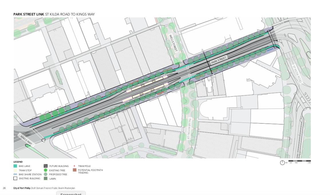
In particular, plans for improving the key St Kilda Rd route have been put on ice.

New promises for this election:   Labor has promised to build separated cycle routes on St Kilda Rd.  While many local residents would prefer curbside lanes allowing them to safely access homes and workplaces, the plan for a cycle way in the centre of the road would be better than the current situation, and be particularly convenient for people travelling from the suburbs to the city.

Labor are also promising an upgrade of the trails network in Melbourne’s northern suburbs.

Liberal Party:  C

Cycling doesn’t seem a priority for the Liberals:  they’ve announced a few tourism-related projects in regional Victoria, and they support minimum passing distance legislation, but there isn’t much else on offer.

More seriously, they would like to grade separate many road intersections.   This would be disastrous for cycling and walking— imagine the mess of St Kilda junction replicated across our city, for example at the intersection of Glen Huntly and Brighton Roads.    It could well be that conditions for cycling will decline under a Liberal government.

Greens:  A

The Greens’ policy includes a $250m commitment to cycling, which will cover (among other things) a 17km Elsternwick-to-Sydney Road separated cycling path, taking in St Kilda Rd and Swanson St on the way.  It is also promising that cycling infrastructure will be funded independently of road works.   

Animal Justice Party:

While the published policies are mostly about animals, in the response to our survey local AJP candidate Tamasin Ramsey said: On the basis of [our] values, we support creating dedicated and separated bike lanes. This gives equal consideration to cyclists, in an environment where cyclists are vulnerable to bike lanes that exist alongside moving traffic, that included a growing number of heavy and imposing vehicles. Supporting cycling is rational because it enhances human health (both physical and mental), engages people with their community, and often improves their engagement with the natural world, including appreciation of – and sensitivity to - other species. All of these factors contribute to the wellbeing of our neighbours and thereby support healthy neighbourhoods.

Now, to the candidates (this is not an exhaustive list— just the ones we were able to make contact with):

ALBERT PARK ELECTORATE

Martin Foley, LABOR (incumbent).   The BUG has met with him twice in last term of government, and while he is clearly interested in and supportive of cycling, we’ve seen very little follow up on the issues we’ve raised, with the notable exception of St Kilda Rd separated lanes.

Andrew Bond (Libs):   As a local councillor, he’s come along on a BUG ride to see local infrastructure issues.  He’s also personally supports the St Kilda Rd separated lanes (not matched by his party).  

Ogy Simic (Greens):  As a local councillor, Ogy has come along on our infrastructure rides and advocated for cycling improvements.  He’s sought out the BUG for comment on various issues and is a frequent bike rider himself.

Tamasin Ramsey (Animal Justice Party).   The AJP is not campaigning strongly on issues related to cycling, but Tamasin often commutes by bike and has a good understanding of the issues facing local cyclists.

BRIGHTON ELECTORATE

James Newbury (Liberals).  James was keen to meet with the BUG before the election.  He doesn’t have much experience cycling, although he does personally support the St Kilda Rd separated lanes project (not matched by his party) and seemed happy to listen to our concerns.  He has been a vocal supporter of a signalised pedestrian crossing of Glen Huntly Rd, at the canal.

Katherine Copsey (Greens).  As a local councillor, Katherine has been an advocate for cycling infrastructure, especially the St Kilda Rd separated lanes and other separated cycle ways, such as the Kerferd Rd improvements.   She has come along on both our infrastructure bike rides, and sought out BUG comment on various issues.   In her response to our survey, she writes: As an everyday cyclist myself I understand the difference dedicated bike infrastructure makes and am committed to advocacy and action so more people than ever can enjoy the freedom, fitness and fun of getting around safely by bike.

PRAHRAN ELECTORATE

Sam Hibbens (Greens), incumbent: In the last term of government Sam Hibbens was able to get the traffic flow on Union St changed, to allow cyclists to travel straight ahead. He had been an advocate for separated lanes on St Kilda Rd and improving safety on Chapel St.

Ogy Simic, Katherine Copsey and BUG members checking out Kerferd Rd.

Ogy Simic, Katherine Copsey and BUG members checking out Kerferd Rd.

Andrew Bond checking out the infrastructure on Fitzroy St

Andrew Bond checking out the infrastructure on Fitzroy St

Responsibility for election comment taken by Julie Clutterbuck, 93 Spray St Elwood.

Victorian State Election: candidate survey

We have an election coming up in November!

Port Phillip BUG has sent a survey to our local candidates (seats of Albert Park, Brighton, and Prahran, and the upper house Southern Metropolitan division). The questions are:

  • Separated cycles lanes are the safest option for cyclists. Will you (and your party) support separated cycle lanes on St Kilda Rd and prioritise installation by 2021?

  • There are many VicRoads controlled roads that are part of the Principal Bicycle Network. Will you (and your party) support VicRoads upgrading the routes in your seat to separated bicycle lanes?

  • Please provide a link to your cycling policy.

  • If you gain office, are there any actions you plan to take, in addition to your party policy, to get more people cycling, more often, and more safely? (Incumbents: you may include actions you've taken over the last term of office).

We’ll post responses here as we receive them. (If you are a candidate and haven’t received a survey, email portphillipbug@gmail.com and we’ll send you the link).

Port Phillip Council's new Transport Strategy: a massive leap forward

The Move Connect Live Integrated Transport Strategy rightly emphasises Active Transport, and backs this up with strategic and ambitions plans for action.

At the heart of the cycling strategy is a plan to build separated cycle lanes along 11 cycling corridors, with plans for 3 more after 2028.   

Proposed cycling corridors. Original map here.

Proposed cycling corridors. Original map here.

This is excellent:  we've seen cycling strategies come and go with mealy-mouthed "action items" focussing on "encouraging behaviour change"  but study after study has shown that the single best way to substantially increase the number of people cycling is to protect them from heavier vehicles.

In the absence of protected lanes, the proportion of trips taken by bike is likely to remain under 3%, undertaken mainly by committed enthusiasts.       By building a network of separated lanes, cities like Seville and London have massively boosted their cycling rates.   Separated lanes also result in higher cycling rates among women, children, and the elderly.

The network proposed is reasonably comprehensive, although Fisherman's Bend seems rather under-served.   

Of course the success of this policy will be in the implementation, but comparing this strategy to our neighbouring councils shows that City of Port Phillip is light years ahead:  Glen Eira's recent Integrated Transport Strategy could come up with no better than to "plan and design a pilot cycle corridor improvement project with a protected cycleway to encourage an increase in cycling"; similarly, Stonnington's cycling strategy has a lot of auditing, liaising, encouraging participation, and "investigating opportunities", but the only plan for actual provision of safe cycling routes is improving some existing off-road trails.  Well done CoPP!

The strategy is not perfect.   Omissions include:

  • Fisherman's Bend needs to be included in the cycle network.

  • The following roads should be included in the network, for construction post-2028 if necessary: Glen Huntly Road; Glen Eira Rd east of Brighton Rd.

  • The signalised crossing of the Elwood Canal with Glen Huntly Road has already been supported by Council, and should appear on either in the pedestrian or cycling section of the plan.

  • The off-road shared/cycle paths form important commuter links, and should be included in the map to give a full picture. These include the cycle lanes in Albert Park, the Sandridge cycle trail, and the Elwood Canal. (The Bay trail is included.)

  • Route 9, labelled as Acland St/Mitford St/Beach St, seems to be mapped to Selwyn Avenue, rather than Beach St.

  • Route 7, Sandringham Line/ Westbury St - Ripponlea to Windsor, should include connection to Glen Eira. There is already a well used route to Glen Huntly Rd on both sides of the railway line east of the railway line, but there needs to be a safe crossing of Hotham St. This route could include a contraflow lane on Lyndon St, which is currently one-way.

Otherwise, an excellent step forward.   

I encourage filling in the survey (before 30th July) to show your support (and identify any other gaps).

Cycling through the Montague-West Gate Freeway Intersection

Janet Bolitho prepared the following submission to the City of Melbourne.

The City of Melbourne wants to enable “residents on the periphery of the City of Melbourne and in neighbouring LGAs to access and travel through the CBD on a comprehensive network of high quality cycle routes“.

The Montague-West Gate Freeway intersection poses a significant barrier to cyclists accessing Docklands and the CBD from Port Melbourne and the south west.

This paper documents safety issues for cyclists accessing the City of Melbourne through this intersection.

Background and context

The Montague-West Gate Freeway intersection is one of the principal access points to Docklands, the City of Melbourne and the west from Port Melbourne and the south west.

The intersection is complex with numerous movements in multiple directions.

In a background report for the Department of Transport to the Fishermans Bend planning process,  GHD found that a total of 39,533 vehicles travelled through this intersection (two-way volume). 20,445 vehicles were recorded in the southbound direction and 19,088 vehicles were recorded in the northbound direction. [GHD for Department of Transport Fishermans Bend Traffic Study Final Report July 2013]

 This study is now five years old and traffic volumes would have increased since then with upgrades to the West Gate Freeway and population growth. Thee figures are quoted to give a sense of the volume of vehicle traffic through this intersection.

Cyclists were not included in that traffic count. Perhaps it was thought that cyclists would not use this intersection and prefer some alternate route. However, since this route is the most direct link between the west and the south west it is used by many cyclists who put their lives at risk every day.

Furthermore, the adopted and agreed Vision for Fishermans Bend is for a population of 80,000 people. With no fewer than 9 development applications of 40 levels in Normanby Road, immediately adjacent to this intersection, there will be significant further pressure on it. The Vision also has a target of 80% of trips to be made by active transport.

For the safety of current users and to keep faith with the vision for Fishermans Bend, supported by the City of Melbourne, safe access for cyclists must be provided through this intersection.

In addition to the issues documented below, many people who are familiar with the traffic light sequence cross against the lights since the wait time between signals is so long.

Some suggestions for immediate improvements are made, but a full safety and access audit needs to be undertaken.

janet1.png
janet2.png

Councillors' tour of the Lake Ward

On Tuesday 12th June we took Port Phillip Councillors Katherine Copsey, Andrew Bond, David Brand, Dick Gross and Ogy Simic on a tour of some interesting sites in the Lake Ward in Port Phillip. (Councillor Tim Baxter and Albert Park MP Martin Foley sent their apologies.)  Lake Ward covers St Kilda, Albert Park, and Middle Park.   The handout with the route is here. I've added some of the extra things we noticed on the ride to the map below (in purple).

11 km. Route taken by Councillors Ride, Lake Ward, June 2018.

We started at St Kilda Town Hall.   The first thing we observed was the time it took for us to walk across the pedestrian crossing at Brighton Road.   These crossings seem optimised for cars, rather than pedestrians.    (A recent article describes this problem.)

L1190738.jpg

We headed up towards the Junction.   We briefly stopped at Inkerman St, where a single car parking place creates a pinch point in a merging zone.

L1190745.jpg

Going up the hill, we looked at how the St Kilda Rd separated bicycle lanes project can be fairly easily implemented as a Copenhagen lane on the edge of the road.   By contrast, the challenge of fitting protected lanes into the Junction are considerable.   However creating a safe way for people on bikes to get through this intersection will be crucial.

L1190751.jpg

We then headed down the bidirectional path on Fitzroy St.  This has been identified as one of the place where cyclists feel most unsafe in surveys by BikeSpot and VicRoads.   There is a protected lane for cyclists, but because drivers do not expect cyclists to be moving in a counterflow direction, they often fail to yield at intersections.   

L1190761.jpg

On the way we tried to use the council public bike pump outside Woolworths.  Unfortunately it deflated Councillor Bond's tyre!   Liz had a pump that we fixed the problem with.

A faulty bike pump.

A faulty bike pump.

Then on through the quiet back streets of West St Kilda to Middle Park shops, where we looked at the suboptimal crossing of Canterbury Rd at Armstrong St.   

L1190769.jpg

From Albert Park, we stopped at the intersection of Albert and Kerferd Rd.   The crossing here is yet another that doesn't allow sufficient time for pedestrians to cross.   There is some new marking for bicycles at this intersection, but the stretch under the tramway (travelling north) is still feels difficult for cyclist.  We looked at the option of converting the pedestrian underpass (just up Ferrars St) to a shared path, giving access to the service road on the north side of Albert Rd.

Looking out of the underpass.

Looking out of the underpass.

Council is planning to put separated cycle lanes on Kerferd Rd, after a trial in which they reduce the number of lanes to one.   

Kerferd Rd is very wide!

Kerferd Rd is very wide!

Our last stop was another parking place, outside Donovans on Marine Parade.   This parking place/loading zone forces on-road cyclists to merge with traffic, while creating a little door zone.   We note that as this is an accessible parking place (for people with a disabled permit) it may be of high utility and should be relocated rather than removed.

L1190817.jpg

Thanks to our councillors and council officer Kathleen Kemp for coming along.  Many thanks to Simon for the photographs.

Sandridge Trail

The Sandridge rail trail is a shared use path that connects Station Pier in Port Melbourne and City Road, just south of the CBD.   It's a pleasant and convenient route, but it falls short of being a high quality off-road route. 

Interactive map is here.

Interactive map is here.

This path is well used by people cycling and walking.  

This path is well used by people cycling and walking.  

Shared path.   When I rode this path on a sunny morning it was well used by cyclists and people walking, particularly older people.   Shared paths are not ideal.  People walking dislike cyclists riding past at moderate cycling speeds (20km/hr), while enforcing a "code of conduct" for pedestrians (e.g requiring that they stay left at all times, avoid walking in groups, and strictly controlling small children and dogs) destroys the pleasure of the walk.   On the other hand, requiring cyclists to ride at slow speeds while passing pedestrians decreases the utility of this as a transport route.    The best practice here would be to create separate paths for walking and cycling, where space allows.

Path loses priority at Bridge St.

Path loses priority at Bridge St.

No crossing at Bridge St.   This needs either a zebra crossing (raised) or a signalised crossing with bike/pedestrian priority.   At the very least, it should have a "keep clear" zone to prevent vehicles from blocking the route while queuing (the gates of the tram crossing are just to the left of the view above).

I'm not sure what works are being done here at Ingles St-- hopefully a better crossing!

I'm not sure what works are being done here at Ingles St-- hopefully a better crossing!

Rails blocking the path.   At the tram depot, the path is blocked by yellow rails that are supposed to force cyclists to give way to trams leaving the depot.     These rails slow cyclists down and are extremely difficult (if not impossible) for people towing trailers, or riding long wheelbase bikes, or riding trikes.    A better solution would be to have gates that close when trams approach, leaving the path unimpeded at all other times.

At the first tram depot crossing.

At the first tram depot crossing.

At the second depot crossing. This gentleman told me that he'd recently slipped and fell on the tram tracks.

At the second depot crossing. This gentleman told me that he'd recently slipped and fell on the tram tracks.

Poor connection to the city.   The trail just ends at City Road, with no clear safe connection across the river to the CBD.

Almost at the city, but not quite!

Almost at the city, but not quite!

Addendum November 2020:   a cargo bike in difficulties at the chicane.

Addendum November 2020: a cargo bike in difficulties at the chicane.

Canal Ward update

Some good news:  Following our bike tour and Ed Cook's petition, Port Phillip Council has supported a crossing with signals on Glen Huntly Rd.    Moreover, they have contributed $50000 towards the cost.  The remaining cost will need to come from VicRoads, and council has written to the roads minister Luke Donnellan requesting this. 

Furthermore, the list of comments and sites was given to Council's Transport Safety Engineering Team.   Here is the list of their responses.

As we have become accustomed to, VicRoads seems to be the biggest hold up, with many comments along the lines of "We'll ask VicRoads if they can do this".   

It's also worrying that they consider a 1.5m wide bike lane (on Brighton Rd) sufficient to avoid the door zone--- Austroads guidance is that on a 60kph road, there should be a buffer of 1-1.5m between cyclists and passing trucks.   So it seems that we can be buffered from the doors, OR the trucks, but not both!

Thanks to everyone who helped.  The Lake Ward tour will be coming up in June.

AF1F8CBA-E55E-416F-BA3A-52F944C80783.jpeg

Councillors' tour of bike infrastructure in the Canal Ward

On Thursday 8th March we took Councillors Katherine Copsey, Tim Baxter and Dick Gross for a tour around the Canal Ward to look at the infrastructure that makes riding a joy... or a nightmare.  (Handout with map and site descriptions here.)


8.35km

It was a beautiful day for a ride!

town-hall.jpg

We observed the absence of a safe crossing on the Canal path at Glen Huntly Road.

glen-huntly.jpg

And discussed the promised counter-flow bike lane on Blessington St--- when will this happen?

blessington.jpg

Thanks to our hard-working councillors Dick, Katherine and Tim, and to Simon for the photos, and to our volunteers Georgie and Rochelle for keeping everyone on track.  

We'll tour the Lakeside and Gateway wards later this year.

The case for Glen Eira Road/Neerim Road as a "safe cycling route"

... in response to Glen Eira's Draft Integrated Transport Strategy

(This is a little out of our council area, but it's my commute so I thought I'd respond.)

Glen Eira Council is currently seeking community feedback on their Integrated Transport Strategy.

The document has some good aspirations, including a shift to 50% active transport modes (public transport, cycling, walking).  However the proposed actions are too feeble to deliver them.

The most glaring absence to me was the absence of Glen Eira Rd/Neerim Rd from the proposed network of "safe cycling streets". 

Draft "safe cycling streets"

Draft "safe cycling streets"

The Glen Eira Rd/Neerim Rd route ought to be included, because:

*There is a very large distance (2.7km) between the nearest east-west routes, Inkerman Rd to the north and Dover St to the south,  which would require a deviation of several kilometres for some cyclists.   Since the most suitable trips for mode switching to cycling are those trips under 5km, this is a large distance.

*This route was part of the Principal Bicycle Network.   It is already a well-used route, as shown by the Strava heat map below, demonstrating the need for a cycling route here.

* Glen Eira road is eminently suited for a main cycling route:  it is very wide, has no tram tracks, and even with fully separated lanes, could still fit a lane of parking along one of the sides of the road.  

* Neerim Rd is currently very narrow, with bikes forced to take the car lane.  Removing parking along this lane to allow a bike lane would increase traffic flow for cars.

* This route has many schools along it (Ripponlea Primary School, Caulfield Grammer, Shelford, Glen Eira, Mt Scopus etc) with poor provision for safe cycling for the students.  It's not clear how the 'Safe School Zones' will work for these schools with no east-west "safe cycling routes" closer than a kilometer away.

*While ideally a completely protected cycling route (as described in the strategy) would be ideal here,  a significant improvement could be made by merely removing parking, or even by removing parking during peak hours.   In this way it would be easy to stage the introduction of improved cycling facilities.  

Make comments on the Glen Eira Integrated Cycling Strategy here

This route is well used.

This route is well used.